नागालैंड
Appearance
नागालैंड | |
|---|---|
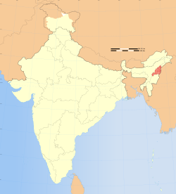
 Location of Nagaland (marked in red) in भारत | |
 Map of Nagaland | |
| Country | |
| Region | Northeast India |
| Formation | 1 December 1963† |
| Capital | Kohima |
| Largest city | Dimapur |
| Districts | 11 |
| Area | |
| • Total | 16,579 किमी2 (6,401 बर्ग मील) |
| • Rank | 25th |
| Population (2011) | |
| • Total | 1,980,602 |
| • Rank | 24th |
| • Density | 119/किमी2 (310/बर्ग मील) |
| Time zone | UTC+05:30 (IST) |
| ISO 3166 code | IN-NL |
| HDI | |
| HDI rank | 4th (2005) |
| Literacy | 80.11% (13th) |
| Official language | English |
| Website | nagaland.nic.in |
| †It was carved out from the State of Assam by the State of Nagaland Act, 1962 | |
नागालैंड भारत के 28 राज्य में से एगो ह। ई के राजधानी कोहिमा में स्थित बा।ई एगो उत्तर पूर्वी राज्य ह।
इहो देखल जाय
[संपादन करीं]संदर्भ
[संपादन करीं]| ई भारत-संबंधी लेख एगो आधार बाटे। जानकारी जोड़ के एकरा के बढ़ावे में विकिपीडिया के मदद करीं। |
