राइन नदी
Appearance
| राइन (Rhenus, Rein, Rhein, le Rhin,[1] Rijn) | |
| नदी | |
राइनलैंड में लोरलेइ चट्टान के लगे राइन नदी
| |
| नाँवउत्पत्ती: सेल्टिक के Rēnos शब्द से | |
| देस | स्विट्जरलैंड, लिख्तेंसटाइन, ऑस्ट्रिया, जर्मनी, फ्रांस, नीदरलैंड |
|---|---|
| राइन बेसिन | स्विट्जरलैंड, लिख्तेंसटाइन, वोरार्लबर्ग, दक्खिनी आ पच्छिमी जर्मनी, उत्तर-पूरबी फ्रांस, बेल्जियम, नीदरलैंड्स, वाल दी लेई, इटली |
| प्रदेश/क्षेत्र | बिचला आ पच्छिमी यूरोप |
| प्राथमिक उदगम | Vorderrhein |
| - लोकेशन | Tomasee, Surselva, Graubünden, स्विट्जरलैंड |
| - ऊँचाई | 2,345 मी (7,694 फीट) |
| - निर्देशांक | 46°37′57″N 8°40′20″E / 46.63250°N 8.67222°E |
| दुसरहा उदगम | Rein Posteriur/Hinterrhein |
| - लोकेशन | पैराडाइज ग्लेशियर, Graubünden, स्विट्जरलैंड |
| सोता के संगम | Reichenau, Switzerland |
| - लोकेशन | Tamins, Graubünden, स्विट्जरलैंड |
| - ऊँचाई | 585 मी (1,919 फीट) |
| - निर्देशांक | 46°49′24″N 9°24′27″E / 46.82333°N 9.40750°E |
| मुहाना | North Sea |
| - लोकेशन | नीदरलैंड |
| - ऊँचाई | 0 मी (0 फीट) |
| - निर्देशांक | 51°58′54″N 4°4′50″E / 51.98167°N 4.08056°Eनिर्देशांक: 51°58′54″N 4°4′50″E / 51.98167°N 4.08056°E |
| लंबाई | 1,230 किमी (764 मील), [note 1] |
| थाला | 185,000 किमी2 (71,429 वर्ग मील) |
| जलनिकास | |
| - औसत | 2,900 m3/s (102,413 cu ft/s) |
| - अधिकतम | 13,000 m3/s (459,091 cu ft/s) |
| - सबसे कम | 800 m3/s (28,252 cu ft/s) |
| यूनेस्को बिस्व धरोहर स्थल | |
| नाँव | ऊपरी बिचली राइन घाटी |
| साल | 2002 (#26) |
| नंबर | 1066 |
| क्षेत्र | यूरोप-उत्तर अमेरिका |
| पैमाना | (ii)(iv)(v) |
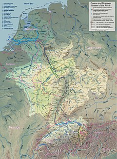
राइन बेसिन के नक्सा
| |
| Wikimedia Commons: राइन | |
| [2] | |
राइन नदी (अंग्रेजी: Rhine) यूरोप महादीप के एक ठो प्रमुख नदी बाटे। ई स्विट्जरलैंड देस में स्विस-आल्प्स के दक्खिनी हिस्सा से निकले ले। आगे बढ़े पर ई नदी स्विट्जरलैंड-लिख्तेंस्टीन, स्विस-ऑस्ट्रियाई, स्विस-जर्मन आ फ्रांस-जर्मनी के बीचा के सीमारेखा बनावे ले। एकरे बाद ई जर्मनी के क्षेत्र राइनलैंड में बहे ले आ आगे जा के नीदरलैंड से हो के नॉर्थ सागर में गिरे ले।
ई डेन्यूब नदी के बाद, सेन्ट्रल आ पूरबी यूरोप में दुसरी सबसे लमहर नदी हवे जेकर लंबाई 1,230 किमी (760 मील) बाटे।[note 1][note 2] एकर कुल औसत जलबहाव 2,900 m3/s (100,000 cu ft/s) हवे।
नोट
[संपादन करीं]- ↑ 1.0 1.1 खाली भर राइन नदी के लंबाई (Rheinkilometer) कौन्स्तेंट्स के बाद ऑफिशियल लंबाई मानल जाला। एकर पूरा लंबाई अल्पाइन राइन के रूप में परिभाषित कइल जाला। साल 2010 में अइसन मीडिया रिपोर्ट आइल रहलीं कि राइन के कुल लंबाई के अधिकतर 20वीं-सदी के ज्ञानकोश सभ में घटा के देखावल गइल बाटे, पत्रकार लोगन के आग्रह पर डच नदी सांख्यिकी (Dutch Rijkswaterstaat) एकर लंबाई 1,232km"Der Rhein ist kürzer als gedacht – Jahrhundert-Irrtum". sueddeutsche.de. Retrieved 27 March 2010.."Rhine River 90 km shorter than everyone thinks". The Local – Germany's news in English. 27 March 2010. Retrieved 9 April 2010. घोषित कइलस आ कहलस कि, "'We checked it out and came to 1,232 kilometres,' said Ankie Pannekoek, spokeswoman for the Dutch government hydrology office." 2018 तक ले [update], the popular press still reports a shorter length of 745 miles (~1,200 kilometers).Sheppard, David; Chazan, Guy (2 November 2018). "Where did the Rhine go? Drought-hit cargo river sparks economic fears". OZY. Archived from the original on 16 July 2019. Retrieved 2 November 2018.
- ↑ The Rhine is cited as the "twelfth-longest river of Europe"[केकरे अनुसार?] if one counts the Russian rivers Volga, Ural, Pechora, Kama, Northern Dvina–Vychegda, Oka, and Belaya, which, based on the modern conventional boundary between Europe and Asia are within European Russia or form part of the boundary with Asia. Also longer than the Rhine are the Eastern European rivers Dnieper, Don, and Dniester, which flow into the Black Sea.
संदर्भ
[संपादन करीं]| ई लेख कौनो नदी के बारे में एगो आधार बाटे। जानकारी जोड़ के एकरा के बढ़ावे में विकिपीडिया के मदद करीं। |


