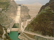
टिहरी बान्ह
Appearance
| टिहरी बान्ह | |
|---|---|
 बंधा 2008 में; कुल गहिराई 855 फीट हवे | |
Location of टिहरी बान्ह in India Uttarakhand | |
| Country | भारत |
| Location | उत्तराखंड |
| Coordinates | 30°22′40″N 78°28′50″E / 30.37778°N 78.48056°Eनिर्देशांक: 30°22′40″N 78°28′50″E / 30.37778°N 78.48056°E |
| Status | Operational |
| Construction began | 1978 |
| Opening date | 2006 |
| Construction cost | US $2.5 बिलियन |
| Owner(s) | THDC INDIA LIMITED |
| Dam and spillways | |
| Type of dam | बंधा (एम्बार्कमेंट), माटी-पाथर भरल |
| Impounds | भागीरथी |
| Height | 260.5 मी (855 फीट) |
| Length | 575 मी (1,886 फीट) |
| Width (crest) | 20 मी (66 फीट) |
| Width (base) | 1,128 मी (3,701 फीट) |
| Spillways | 2 |
| Spillway type | गेट कंट्रोल वाला |
| Spillway capacity | 15,540 m3/s (549,000 cu ft/s) |
| Reservoir | |
| Total capacity | 4.0 किमी3 (3,200,000 एकड़·फीट) |
| Surface area | 52 किमी2 (560,000,000 वर्ग फु) |
| Power station | |
| Commission date | 2006 |
| Type | Pumped-storage |
| Turbines | फ्रांसिस पंप टरबाइन |
| Installed capacity | 1,000 मेगावाट (1,300,000 hp) Max. planned: 2,400 MW |
टिहरी बान्ह (अंग्रेजी: Tehri Dam) भारत के उत्तराखंड राज्य में एगो बान्ह बाटे। ई भागीरथी नदी (आ भिलंगना नदी के संगम) पर बनल बंधा हवे जे सिंचनी, पिए के पानी के सप्लाई आ बिजली उत्पादन खाती बनल बान्ह हवे। ई भारत के सभसे ऊँच बान्ह हवे आ दुनिया के कुछ सभसे ऊँच बान्हन में से एक बा।
इहो देखल जाय
[संपादन करीं]संदर्भ
[संपादन करीं]| ई भारत के कौनों अस्थान भा भूगोल से संबंधित लेख एगो आधार बाटे। जानकारी जोड़ के एकरा के बढ़ावे में विकिपीडिया के मदद करीं। |

