साओ पालो
Appearance
São Paulo | |||
|---|---|---|---|
| Município de São Paulo Municipality of São Paulo | |||
 From the top, left to right: Octávio Frias de Oliveira Bridge; São Paulo Museum of Art at Paulista Avenue; São Paulo Cathedral; overview of the historic downtown; Ibirapuera Park; Luz Station and panoramic view of the city at night. | |||
| |||
| Nicknames: Terra da Garoa (Land of Drizzle) and Sampa | |||
| Mottoes: | |||
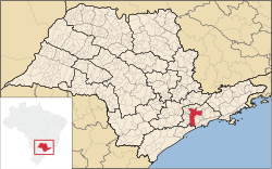
 Location in the state of São Paulo | |||
| Country | |||
| Region | Southeast | ||
| State | |||
| Founded | जनवरी 25, 1554 | ||
| Government | |||
| • Mayor | Fernando Haddad (PT (2013–2016)) | ||
| Area | |||
| • Metro | 7,943.8 किमी2 (3,067.1 बर्ग मील) | ||
| Elevation | 760 m (2,493.4 ft) | ||
| Population (2014)[1] | |||
| • Rank | 1st | ||
| • Density | 7,762.3/किमी2 (20,104/बर्ग मील) | ||
| • Urban | 11,895,893 | ||
| • Metro | 20,935,204 | ||
| • Metro density | 2,469.35/किमी2 (6,395.6/बर्ग मील) | ||
| Demonym | Paulistano | ||
| Time zone | UTC−3 (BRT) | ||
| • Summer (DST) | UTC−2 (BRST) | ||
| Postal Code (CEP) | 01000-000 | ||
| Area code | (+55) 11 | ||
| Website | São Paulo, SP | ||
साओ पालो ब्राजील के आ दुनिया के एगो प्रमुख शहर ह।
संदर्भ
[संपादन करीं]- ↑ "2014 population estimates. Brazilian Institute of Geography and Statistics (IBGE) (1 July 2014)" (PDF). Ibge.gov.br. Retrieved सितंबर 14, 2014.
| ई भूगोल-संबंधित लेख एगो आधार बाटे। जानकारी जोड़ के एकरा के बढ़ावे में विकिपीडिया के मदद करीं। |


