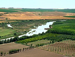
दज़ला नदी
Appearance
| दज़ला नदी | |
| River | |
About 100 km from its source, the Tigris enables rich agriculture outside Diyarbakır, Turkey.
| |
| देस | Turkey, Syria, Iraq |
|---|---|
| सहायिका | |
| - दहिने से | Wadi Tharthar |
| शहर | Diyarbakır, Mosul, Baghdad |
| उदगम | Lake Hazar |
| - ऊँचाई | 1,150 मी (3,773 फीट) |
| - निर्देशांक | 38°29′0″N 39°25′0″E / 38.48333°N 39.41667°E |
| मुहाना | Shatt al-Arab |
| - लोकेशन | Al-Qurnah, Basra Governorate, Iraq |
| लंबाई | 1,850 किमी (1,150 मील) |
| थाला | 375,000 किमी2 (144,788 वर्ग मील) |
| जलनिकास | for Baghdad |
| - औसत | 1,014 m3/s (35,809 cu ft/s) |
| - अधिकतम | 2,779 m3/s (98,139 cu ft/s) |
| - सबसे कम | 337 m3/s (11,901 cu ft/s) |
| [1] [2] | |
दज़ला नदी (अंग्रेजी: Tigris river) एशिया महादीप के एक ठो प्रमुख नदी बाटे।
संदर्भ
[संपादन करीं]- ↑ Isaev, V.A.; Mikhailova, M.V. (2009). "The hydrology, evolution, and hydrological regime of the mouth area of the Shatt al-Arab River". Water Resources. 36 (4): 380–395. doi:10.1134/S0097807809040022.
- ↑ Kolars, J.F.; Mitchell, W.A. (1991). The Euphrates River and the Southeast Anatolia Development Project. Carbondale: Southern Illinois University Press. pp. 6–8. ISBN 0-8093-1572-6.
| ई लेख कौनो नदी के बारे में एगो आधार बाटे। जानकारी जोड़ के एकरा के बढ़ावे में विकिपीडिया के मदद करीं। |


