कैनबरा
Appearance
| कैनबरा अस्ट्रेलिया राजधानी क्षेत्र | |||||||||
|---|---|---|---|---|---|---|---|---|---|
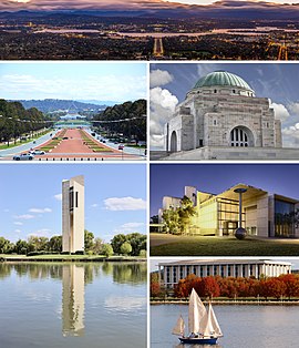
 Canberra, from top left to bottom right–the city viewed from Mount Ainslie, the Land Axis featuring Old Parliament House and New Parliament House, the Australian War Memorial, the National Carillon, the National Gallery of Australia and the National Library of Australia on Lake Burley Griffin | |||||||||
 City map plan of Canberra. | |||||||||
| निर्देशांक | 35°18′27″S 149°07′27.9″E / 35.30750°S 149.124417°Eनिर्देशांक: 35°18′27″S 149°07′27.9″E / 35.30750°S 149.124417°E | ||||||||
| जनसंख्या | 410,301 (2017)[1] (8th) | ||||||||
| • जन घनत्व | 428.6/किमी२ (1,110/वर्ग माइल) | ||||||||
| स्थापना | 12 मार्च 1913 | ||||||||
| उंचाई | 578 मी (1,896 फीट)[2] | ||||||||
| क्षेत्रफल | 814.2 किमी२ (314.4 वर्ग माइल)[3] | ||||||||
| समय क्षेत्र | AEST (यूटिसी+10:00) | ||||||||
| • ग्रीष्म (डीएसटि) | AEDT (यूटिसी+11:00) | ||||||||
| स्थान | |||||||||
| |||||||||
कैनबरा ऑस्ट्रेलिया में एगो शहर आ एह देस के राजधानी बाटे।
भूगोल
[संपादन करीं]जलवायु
[संपादन करीं]| कैनबरा हवाईअड्डा खातिर जलवायु आँकड़ा | |||||||||||||
|---|---|---|---|---|---|---|---|---|---|---|---|---|---|
| महीना | जन | फर | मार्च | अप्रै | मई | जून | जुला | अग | सित | अक्टू | नवं | दिस | सालभर |
| रिकार्ड अधिकतम °C (°F) | 42.0 (107.6) |
42.2 (108) |
37.5 (99.5) |
32.6 (90.7) |
24.5 (76.1) |
20.1 (68.2) |
19.7 (67.5) |
24.0 (75.2) |
28.6 (83.5) |
32.7 (90.9) |
39.9 (103.8) |
39.2 (102.6) |
42.2 (108) |
| औसत अधिकतम °C (°F) | 28.0 (82.4) |
27.1 (80.8) |
24.5 (76.1) |
20.0 (68) |
15.6 (60.1) |
12.3 (54.1) |
11.4 (52.5) |
13.0 (55.4) |
16.2 (61.2) |
19.4 (66.9) |
22.7 (72.9) |
26.1 (79) |
19.7 (67.5) |
| औसत कम °C (°F) | 13.2 (55.8) |
13.1 (55.6) |
10.7 (51.3) |
6.7 (44.1) |
3.2 (37.8) |
1.0 (33.8) |
−0.1 (31.8) |
1.0 (33.8) |
3.3 (37.9) |
6.1 (43) |
8.8 (47.8) |
11.4 (52.5) |
6.5 (43.7) |
| रिकार्ड सबसे कम °C (°F) | 1.6 (34.9) |
3.0 (37.4) |
−1.1 (30) |
−3.7 (25.3) |
−7.5 (18.5) |
−8.5 (16.7) |
−10.0 (14) |
−8.5 (16.7) |
−6.8 (19.8) |
−3.4 (25.9) |
−1.8 (28.8) |
0.3 (32.5) |
−10.0 (14) |
| औसत वर्षण मिमी (इंच) | 58.5 (2.303) |
56.4 (2.22) |
50.7 (1.996) |
46.0 (1.811) |
44.4 (1.748) |
40.4 (1.591) |
41.4 (1.63) |
46.2 (1.819) |
52.0 (2.047) |
62.4 (2.457) |
64.4 (2.535) |
53.8 (2.118) |
616.4 (24.268) |
| औसत बरखा वाला दिन | 7.3 | 6.7 | 6.9 | 7.3 | 8.4 | 9.8 | 10.5 | 11.1 | 10.2 | 10.4 | 9.8 | 7.8 | 106.2 |
| औसत माहवार दिन लंबाई | 294.5 | 254.3 | 251.1 | 219 | 186 | 156 | 179.8 | 217 | 231 | 266.6 | 267 | 291.4 | 2,813.7 |
| Source #1: Climate averages for Canberra Airport Comparison (1939–2010)[9] | |||||||||||||
| Source #2: Special climate statements and climate summaries for more recent extremes[10] | |||||||||||||
संदर्भ
[संपादन करीं]- ↑ "3218.0 – Regional Population Growth, Australia, 2015–16:ESTIMATED RESIDENT POPULATION – Australia's capital city populations, जून 2017". Australian Bureau of Statistics. Australian Bureau of Statistics. Retrieved 25 नवंबर 2018.
{{cite web}}: CS1 maint: url-status (link) Estimated resident population, 30 जून 2017. - ↑ "GFS / BOM data for CANBERRA AIRPORT". Retrieved 16 जून 2018.
- ↑ "Planning Data Statistics". ACT Planning & Land Authority. 21 जुलाई 2009. Archived from the original on 2 अगस्त 2008. Retrieved 13 मई 2010.
- ↑ "Great Circle Distance between CANBERRA and SYDNEY". Geoscience Australia. मार्च 2004.
- ↑ "Great Circle Distance between CANBERRA and MELBOURNE". Geoscience Australia. मार्च 2004.
- ↑ "Great Circle Distance between CANBERRA and ADELAIDE". Geoscience Australia. मार्च 2004.
- ↑ "Great Circle Distance between CANBERRA and BRISBANE". Geoscience Australia. मार्च 2004.
- ↑ "Great Circle Distance between CANBERRA and PERTH". Geoscience Australia. मार्च 2004.
- ↑ "Climate statistics for Australian locations: Canberra Airport Comparison". मौसमबिज्ञान ब्यूरो. Retrieved 9 जुलाई 2015.
- ↑
- "Special climate statement 36 – Unseasonal cold in southeast Australia" (PDF). Bureau of Meteorology. 13 जनवरी 2012. Retrieved 9 जुलाई 2015.
- "ACT in September 2012". Bureau of Meteorology. 2 अक्टूबर 2012. Retrieved 9 जुलाई 2015.
- "ACT in दिसंबर 2012". Bureau of Meteorology. 2 जनवरी 2013. Retrieved 9 जुलाई 2015.
- "Special Climate Statement 43 – extreme heat in जनवरी 2013" (PDF). Bureau of Meteorology. 1 फरवरी 2013. Retrieved 9 जुलाई 2015.
- "ACT in अक्टूबर 2013". Bureau of Meteorology. 1 नवंबर 2013. Retrieved 9 जुलाई 2015.
| विकिमीडिया कॉमंस पर संबंधित मीडिया Canberra पर मौजूद बा। |
| ई ऑस्ट्रेलिया के भूगोल-संबंधी लेख एगो आधार बाटे। जानकारी जोड़ के एकरा के बढ़ावे में विकिपीडिया के मदद करीं। |
