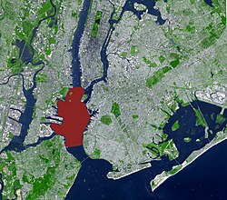
ऊपरी न्यू यॉर्क खाड़ी
निर्देशांक: 40°40′06″N 74°02′44″W / 40.66833°N 74.04556°W

ऊपरी न्यू यॉर्क खाड़ी (अंग्रेजी: Upper New York Bay), न्यूयॉर्क आ न्यूजर्सी बंदरगाह के इलाका बाली खाड़ी के कहल जाला। ई हडसन नदी के मुहाना हवे। एकरा किनारे न्यू यॉर्क शहर के मैनहट्टन बरो, ब्रूकलिन, आ स्टाटेन दीप अउरी हडसन काउंटी, न्यू जर्सी आ Bayonne मौजूद बाड़ें।[1]
संदर्भ[संपादन करीं]
- ↑ Hudson County New Jersey Street Map. Hagstrom Map Company, Inc. 2008. ISBN 0-88097-763-9.
| ई अमेरिका (यूएसए) के जगह संबंधी लेख एगो आधार बाटे। जानकारी जोड़ के एकरा के बढ़ावे में विकिपीडिया के मदद करीं। |
