
चित्र:Relief Map of Germany, Black Forest.png

ए नमूना के साइज: 506 × 600 पिक्सेल. अउरी रिजोल्यूशन: 202 × 240 पिक्सेल | 405 × 480 पिक्सेल | 1,000 × 1,185 पिक्सेल.
ओरिजनल फाइल (1,000 × 1,185 पिक्सेल, फाइल साइज: 1.48 MB, MIME टाइप: image/png)
सारांश
| बिबरण |
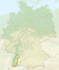
English: Relief map of Germany with outlines of the Black Forest. Equirectangular projection, N/S stretching 150 %. Geographic limits of the map: * N: 55.1° N * S: 47.2° N * W: 5.5° E * E: 15.5° E
Deutsch: Deutschlandkarte mit Umrissen des Schwarzwalds gemäß Naturräumlichen Großregionen Deutschlands nach dem System des Bundesamtes für Naturschutz (BfN). |
| तारीख | (UTC) |
| स्रोत |
This file was derived from: |
| लेखक |
|


लाइसेंसिंग
ई फाइल Creative Commons Attribution-Share Alike 3.0 Unported लाइसेंस की तहत लाइसेंसी बा।
- आप फ्री बानी:
- साझा करे खातिर – रचना के नकल करे, बाँटे आ दुसरी जगह भेजे खातिर
- रीमिक्स करे खातिर – काम के अपनी हिसाब से बनावे खातिर
- नीचे दिहल कारणन की तहत:
- एट्रीब्यूशन – लाइसेंस के कड़ी दे के उचित श्रेय (क्रेडिट) दिहल जरूरी बा आ अगर कौनों बदलाव कइल गइल बा तब ओहू के बतावल जाए के चाहीं। आप ई काम कौनों उचित तरीका से क सकत बानी, बाकी ई न झलके के चाहीं की जेकरा लगे लाइसेंस बा ऊ राउर चाहे राउर काम के समर्थन करत बाटे या सही बतावत बा।
- शेयर अलाइक (share alike) – अगर आप एह सामग्री के आधार बना के कुछ रिमिक्स करत बानी, रूप बदलाव करत बानी, चाहे कुछ जोड़ के सामग्री के बढ़ावत बानी, आपके आपन योगदान ठीक एही या कंपेटिबल लाइसेंस जइसन कि ओरिजनल बाटे, के तहत होखे के चाहीं।
Original upload log
This image is a derivative work of the following images:
- File:Relief_Map_of_Germany.png licensed with Cc-by-sa-3.0
- 2010-08-28T17:48:23Z Виктор В 1000x1185 (1796090 Bytes) Рельеф дна
- 2010-08-28T16:40:16Z Виктор В 1000x1185 (1733013 Bytes) мелкие исправления
- 2010-08-28T12:03:54Z Виктор В 1000x1185 (1766531 Bytes) == {{int:filedesc}} == {{Information |Description={{en|Relief map of [[:en:Germany|Germany]]}} [[:en:Equirectangular projection|Equirectangular projection]], N/S stretching 150 %. Geographic limits of the map: * N: 55.1° N *
- File:Deutschland_Naturraeumliche_Grossregionen.png licensed with Cc-by-sa-3.0, GFDL
- 2011-09-29T17:01:59Z NordNordWest 1826x2318 (5659071 Bytes) upd
- 2011-09-22T18:51:25Z NordNordWest 1826x2318 (5641169 Bytes) ergänzt
- 2011-09-14T18:57:42Z NordNordWest 1826x2318 (5615307 Bytes) update
- 2008-06-12T10:16:41Z NordNordWest 1980x2322 (5911072 Bytes)
- 2008-06-12T09:03:16Z NordNordWest 1979x2322 (5753037 Bytes)
- 2008-06-11T19:04:47Z NordNordWest 1979x2321 (5766960 Bytes) == Beschreibung == {{Information |Description= {{de|Karte der [[:de:Naturräumliche Haupteinheiten Deutschlands|Naturräumlichen Haupteinheiten Deutschlands]] nach dem System des [[:de:Bundesamt für Naturschutz|Bundesamtes f
Uploaded with derivativeFX
फाइल के इतिहास
ओ समय ई फाइल कइसन लउके ई देखे खातिर कौनों तारीख/समय पर क्लिक करीं।
| तारीख/समय | चिप्पी रूप | डाइमेंशन | प्रयोगकर्ता | टिप्पणी | |
|---|---|---|---|---|---|
| वर्तमान | 02:40, 28 जुलाई 2013 | | 1,000 × 1,185 (1.48 MB) | Sitacuisses | == {{int:filedesc}} == {{Information |Description={{en|Relief map of Germany with outlines of the Black Forest. Equirectangular projection, N/S stretching 150 %. Geographic limits ... |
फाइल के उपयोग
फाइल के इस्तेमाल पन्ना करत बा:
बैस्विक फाइल उपयोग
नीचे दिहल अउरी विकिसभ पर एह फाइल के इस्तेमाल हो रहल बा:
- af.wikipedia.org पर इस्तेमाल
- arz.wikipedia.org पर इस्तेमाल
- ast.wikipedia.org पर इस्तेमाल
- bn.wikipedia.org पर इस्तेमाल
- ca.wikipedia.org पर इस्तेमाल
- cs.wikipedia.org पर इस्तेमाल
- da.wikipedia.org पर इस्तेमाल
- de.wikipedia.org पर इस्तेमाल
- en.wikipedia.org पर इस्तेमाल
- en.wikivoyage.org पर इस्तेमाल
- eo.wikipedia.org पर इस्तेमाल
- es.wikipedia.org पर इस्तेमाल
- eu.wikipedia.org पर इस्तेमाल
- fa.wikipedia.org पर इस्तेमाल
- fi.wikipedia.org पर इस्तेमाल
- fr.wikipedia.org पर इस्तेमाल
- ga.wikipedia.org पर इस्तेमाल
- he.wikipedia.org पर इस्तेमाल
- it.wikivoyage.org पर इस्तेमाल
- ja.wikipedia.org पर इस्तेमाल
- ka.wikipedia.org पर इस्तेमाल
- ml.wikipedia.org पर इस्तेमाल
- pl.wikipedia.org पर इस्तेमाल
- pl.wikivoyage.org पर इस्तेमाल
- ro.wikipedia.org पर इस्तेमाल
- sco.wikipedia.org पर इस्तेमाल
- sk.wikipedia.org पर इस्तेमाल
- sl.wikipedia.org पर इस्तेमाल
- ta.wikipedia.org पर इस्तेमाल
- th.wikipedia.org पर इस्तेमाल
- tr.wikipedia.org पर इस्तेमाल
- ur.wikipedia.org पर इस्तेमाल
- www.wikidata.org पर इस्तेमाल
- zh.wikipedia.org पर इस्तेमाल