
चित्र:Philippines location map.svg

Size of this PNG preview of this SVG file: 454 × 599 पिक्सेल. अउरी रिजोल्यूशन: 182 × 240 पिक्सेल | 364 × 480 पिक्सेल | 582 × 768 पिक्सेल | 776 × 1,024 पिक्सेल | 1,552 × 2,048 पिक्सेल | 1,871 × 2,468 पिक्सेल.
ओरिजनल फाइल (एसवीजी फाइल, नॉमिनली 1,871 x 2,468 पिक्सल, फाइल के आकार: 2.18 MB)
सारांश
| बिबरण |
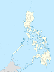
Deutsch: Positionskarte der Philippinen
Quadratische Plattkarte, N-S-Streckung 103 %. Geographische Begrenzung der Karte:
English: Location map of the Philippines
Equirectangular projection, N/S stretching 103 %. Geographic limits of the map:
|
| तारीख | |
| स्रोत |
own work, using
|
| लेखक | NordNordWest |
| Other versions |
|


|
This map has been made or improved in the German Kartenwerkstatt (Map Lab). You can propose maps to improve as well.
|
लाइसेंसिंग
I, the copyright holder of this work, hereby publish it under the following licenses:

|
जीएनयू फ्री डाकुमेंटेशन लाइसेंस, वर्जन 1.2 या फिर कौनो भी बाद के प्रकाशित फ्री साफ्टवेयर फाउंडेशन लाइसेंस के शर्त के तहत, एह डाकुमेंट के नकल करे, बितरण करे आ/भा बदलाव करे के परमीशन दिहल गइल बा; एह में इनवैरिएंट खंड सभ नइखे शामिल, मुखपृष्ट के पाठ नइखे शामिल, आ बैक-कभर के पाठ नइखे शामिल। लाइसेंस के एगो प्रति जीएनयू फ्री डाकुमेंटेशन लाइसेंस नाँव के खंड में दिहल गइल बा। |
This file is licensed under the Creative Commons Attribution 3.0 Unported license.
- आप फ्री बानी:
- साझा करे खातिर – रचना के नकल करे, बाँटे आ दुसरी जगह भेजे खातिर
- रीमिक्स करे खातिर – काम के अपनी हिसाब से बनावे खातिर
- नीचे दिहल कारणन की तहत:
- एट्रीब्यूशन – लाइसेंस के कड़ी दे के उचित श्रेय (क्रेडिट) दिहल जरूरी बा आ अगर कौनों बदलाव कइल गइल बा तब ओहू के बतावल जाए के चाहीं। आप ई काम कौनों उचित तरीका से क सकत बानी, बाकी ई न झलके के चाहीं की जेकरा लगे लाइसेंस बा ऊ राउर चाहे राउर काम के समर्थन करत बाटे या सही बतावत बा।
रउआँ अपनी जरूरत के लाइसेंस बीछ सकत बानीं।
फाइल के इतिहास
ओ समय ई फाइल कइसन लउके ई देखे खातिर कौनों तारीख/समय पर क्लिक करीं।
| तारीख/समय | चिप्पी रूप | डाइमेंशन | प्रयोगकर्ता | टिप्पणी | |
|---|---|---|---|---|---|
| वर्तमान | 22:17, 25 मार्च 2016 | | 1,871 × 2,468 (2.18 MB) | Man77 | upd NIR, Davao |
| 11:46, 14 अक्टूबर 2013 |  | 1,871 × 2,468 (2.2 MB) | Hariboneagle927 | fix | |
| 11:07, 14 अक्टूबर 2013 |  | 1,871 × 2,468 (2.15 MB) | Hariboneagle927 | fix. Cagayan | |
| 10:58, 14 अक्टूबर 2013 |  | 1,871 × 2,468 (2.15 MB) | Hariboneagle927 | Made some update and corrected some minor errors. | |
| 07:22, 9 अक्टूबर 2013 |  | 1,871 × 2,468 (2.14 MB) | Hellerick | Regrouped for easier recoloring. | |
| 06:13, 7 अगस्त 2013 |  | 1,871 × 2,468 (1.07 MB) | Hellerick | Regional division replaced with provincial division. | |
| 19:09, 5 जुलाई 2009 |  | 1,871 × 2,468 (1,009 KB) | NordNordWest | ||
| 21:04, 25 मई 2009 |  | 1,687 × 2,469 (999 KB) | NordNordWest | {{Information |Description= {{de|Positionskarte der Philippinen}} Quadratische Plattkarte, N-S-Streckung 103 %. Geographische Begrenzung der Karte: * N: 21.2° N * S: 4.3° N * W: 115.4° O * O: 127.3° O {{en|Location map of the [[:en |
फाइल के उपयोग
कौनों पन्ना नइखे जवन ए फाइल के इस्तेमाल करत होखे।
बैस्विक फाइल उपयोग
नीचे दिहल अउरी विकिसभ पर एह फाइल के इस्तेमाल हो रहल बा:
- af.wikipedia.org पर इस्तेमाल
- als.wikipedia.org पर इस्तेमाल
- an.wikipedia.org पर इस्तेमाल
- az.wikipedia.org पर इस्तेमाल
- be-tarask.wikipedia.org पर इस्तेमाल
- be.wikipedia.org पर इस्तेमाल
- bn.wikipedia.org पर इस्तेमाल
- ce.wikipedia.org पर इस्तेमाल
- ckb.wikipedia.org पर इस्तेमाल
- crh.wikipedia.org पर इस्तेमाल
- cs.wikipedia.org पर इस्तेमाल
एह फाइल के अउरी बैस्विक इस्तेमाल देखीं