
चित्र:Punjab in India.png
Punjab_in_India.png (350 × 426 पिक्सेल, फाइल साइज: 76 KB, MIME टाइप: image/png)
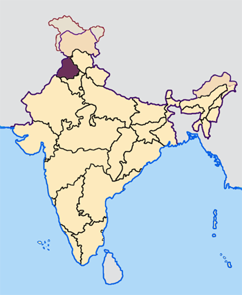
Map made by me, Nichalp
Note: The Indian state of w:Jammu and Kashmir is claimed by w:India, w:Pakistan and the w:People's Republic of China. This map depicts the boundaries of the state as it was in 1947. Areas administered by India is coloured as per the rest of the states, and the area administered by Pakistan and China are coloured in a neutral colour. See the map of Jammu and Kashmir.
The Indian state of w:Arunachal Pradesh is claimed by China as a part of w:South Tibet. The claimed region is depicted in a pale shade of pink. See the map of Arunachal Pradesh.
The Indian territorial waters extend to a distance of twelve nautical miles.

|
जीएनयू फ्री डाकुमेंटेशन लाइसेंस, वर्जन 1.2 या फिर कौनो भी बाद के प्रकाशित फ्री साफ्टवेयर फाउंडेशन लाइसेंस के शर्त के तहत, एह डाकुमेंट के नकल करे, बितरण करे आ/भा बदलाव करे के परमीशन दिहल गइल बा; एह में इनवैरिएंट खंड सभ नइखे शामिल, मुखपृष्ट के पाठ नइखे शामिल, आ बैक-कभर के पाठ नइखे शामिल। लाइसेंस के एगो प्रति जीएनयू फ्री डाकुमेंटेशन लाइसेंस नाँव के खंड में दिहल गइल बा। |
| ई फाइल Creative Commons Attribution-Share Alike 3.0 Unported लाइसेंस की तहत लाइसेंसी बा। | ||
| ||
| This licensing tag was added to this file as part of the GFDL licensing update. |
फाइल के इतिहास
ओ समय ई फाइल कइसन लउके ई देखे खातिर कौनों तारीख/समय पर क्लिक करीं।
| तारीख/समय | चिप्पी रूप | डाइमेंशन | प्रयोगकर्ता | टिप्पणी | |
|---|---|---|---|---|---|
| वर्तमान | 07:33, 23 अप्रैल 2005 | | 350 × 426 (76 KB) | Nichalp | NPOV map |
| 07:22, 23 अप्रैल 2005 |  | 200 × 231 (22 KB) | Kerpal | Reverted to earlier revision | |
| 06:27, 23 अप्रैल 2005 |  | 500 × 608 (121 KB) | Nichalp | Reverted to earlier revision | |
| 05:00, 23 अप्रैल 2005 |  | 200 × 231 (22 KB) | Kerpal | Reverted to earlier revision | |
| 04:54, 23 अप्रैल 2005 |  | 500 × 608 (121 KB) | Nichalp | Reverted to earlier revision | |
| 21:06, 22 अप्रैल 2005 |  | 200 × 231 (22 KB) | Kerpal | Reverted to earlier revision | |
| 13:38, 22 अप्रैल 2005 |  | 500 × 608 (121 KB) | Nichalp | Reverted to earlier revision | |
| 09:43, 22 अप्रैल 2005 |  | 200 × 231 (22 KB) | Kerpal | originally by en:User:Morwen | |
| 18:06, 21 अप्रैल 2005 |  | 500 × 608 (121 KB) | Nichalp | ---- Map made by me, ~~~ ---- Note: The Indian state of w:Jammu and Kashmir is claimed by w:India, w:Pakistan and the w:People's Republic of China. This map depicts the boundaries of the state as it was in 1947. Areas administered by Indi |
फाइल के उपयोग
फाइल के इस्तेमाल 22 पन्ना करत बाड़ें:
- अमृतसर जिला
- कपूरथला जिला
- गुरदासपुर जिला
- जालंधर जिला
- तरनतारन जिला
- पटियाला जिला
- पठानकोट जिला
- फजिल्का जिला
- फतेहगढ़ साहिब जिला
- फरीदकोट जिला
- फिरोजपुर जिला
- बरनाला जिला
- भटिंडा जिला
- मानसा जिला
- मोगा जिला
- रूपनगर जिला
- लुधियाना जिला
- शहीद भगत सिंह नगर जिला
- श्री मुक्तसर साहिब जिला
- संगरूर जिला
- होशियारपुर जिला
- टेम्पलेट:पंजाब
बैस्विक फाइल उपयोग
नीचे दिहल अउरी विकिसभ पर एह फाइल के इस्तेमाल हो रहल बा:
- awa.wikipedia.org पर इस्तेमाल
- bn.wikipedia.org पर इस्तेमाल
- bxr.wikipedia.org पर इस्तेमाल
- en.wikipedia.org पर इस्तेमाल
- Bhangra (music)
- Gurmukhi
- Punjab
- Patiala
- Chandigarh
- Amritsar
- Ludhiana
- Jalandhar
- Punjabi cuisine
- Bathinda
- Punjabis
- Punjabi Suba movement
- Music of Punjab
- Vaisakhi
- Mohali
- Lohri
- Faridkot, India
- Punjab Police (India)
- Gurdaspur district
- Hoshiarpur district
- Jutti
- Amritsar district
- Mansa, Punjab
- Mansa district, India
- Gogaji
- Sangrur
- Pathankot
- Nanakshahi calendar
- Bathinda district
- Patiala district
- Kapurthala district
- Firozpur district
- Phulkari
- Jalandhar district
- Faridkot district
- Ludhiana district
- Sri Muktsar Sahib district
- Rupnagar district
- Moga district
- Shaheed Bhagat Singh Nagar district
- Patiala salwar
- Doaba
- Majha
एह फाइल के अउरी बैस्विक इस्तेमाल देखीं