
चित्र:Loo Winds India Pakistan Map.jpg
ए नमूना के साइज: 448 × 600 पिक्सेल. अउरी रिजोल्यूशन: 179 × 240 पिक्सेल | 359 × 480 पिक्सेल | 680 × 910 पिक्सेल.
ओरिजनल फाइल (680 × 910 पिक्सेल, फाइल साइज: 144 KB, MIME टाइप: image/jpeg)
| बिबरण |
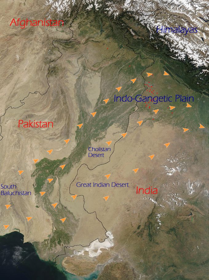
English: The orange arrows indicate how the Loo originates in the deserts of Thar (Great Indian Desert), Cholistan and Baluchistan and flow eastwards towards the entire western part of the Indo-Gangetic plain. |
|||||
| स्रोत | NASA (http://www.visibleearth.nasa.gov/view_rec.php?id=4716) | |||||
| लेखक | NASA | |||||
| परमीशन (एह फाइल के दुबारा इस्तेमाल) |
|

This is derived from an original NASA satellite map modified (by me) to indicate directions of Loo winds. To remove any doubt, I also hereby release any changes added to the original image by me to the public domain. No rights whatsoever are claimed.
फाइल के इतिहास
ओ समय ई फाइल कइसन लउके ई देखे खातिर कौनों तारीख/समय पर क्लिक करीं।
| तारीख/समय | चिप्पी रूप | डाइमेंशन | प्रयोगकर्ता | टिप्पणी | |
|---|---|---|---|---|---|
| वर्तमान | 21:21, 20 जून 2009 | | 680 × 910 (144 KB) | Hunnjazal | {{Information |Description={{en|1=The orange arrows indicate how the Loo originates in the deserts of Thar (Great Indian Desert), Cholistan and Baluchistan and flow eastwards towards the entire western part of the Indo-Gangetic plain.}} |Source=NASA (http |
फाइल के उपयोग
फाइल के इस्तेमाल पन्ना करत बा:
बैस्विक फाइल उपयोग
नीचे दिहल अउरी विकिसभ पर एह फाइल के इस्तेमाल हो रहल बा:
- ar.wikipedia.org पर इस्तेमाल
- bn.wikipedia.org पर इस्तेमाल
- ca.wikipedia.org पर इस्तेमाल
- en.wikipedia.org पर इस्तेमाल
- es.wikipedia.org पर इस्तेमाल
- ml.wikipedia.org पर इस्तेमाल
- nn.wikipedia.org पर इस्तेमाल
- pa.wikipedia.org पर इस्तेमाल
- ru.wikipedia.org पर इस्तेमाल
- uk.wikipedia.org पर इस्तेमाल
- www.wikidata.org पर इस्तेमाल