
चित्र:India districts.png

ए नमूना के साइज: 800 × 548 पिक्सेल. अउरी रिजोल्यूशन: 320 × 219 पिक्सेल | 640 × 439 पिक्सेल | 1,024 × 702 पिक्सेल | 1,281 × 878 पिक्सेल.
ओरिजनल फाइल (1,281 × 878 पिक्सेल, फाइल साइज: 44 KB, MIME टाइप: image/png)
सारांश

|
This file requires updating. In doing so, you could add a timestamp to the file.
|
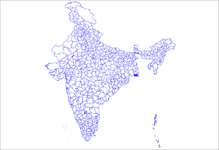
Map of the districts of India. Created by Rarelibra 18:25, 12 April 2007 (UTC) for public domain use, using MapInfo Professional v8.5 and various mapping resources.
लाइसेंसिंग
| I, the copyright holder of this work, release this work into the public domain. This applies worldwide. In some countries this may not be legally possible; if so: I grant anyone the right to use this work for any purpose, without any conditions, unless such conditions are required by law. |
फाइल के इतिहास
ओ समय ई फाइल कइसन लउके ई देखे खातिर कौनों तारीख/समय पर क्लिक करीं।
| तारीख/समय | चिप्पी रूप | डाइमेंशन | प्रयोगकर्ता | टिप्पणी | |
|---|---|---|---|---|---|
| वर्तमान | 18:25, 12 अप्रैल 2007 | | 1,281 × 878 (44 KB) | Rarelibra | Map of the districts of India. Created by ~~~~ for public domain use, using MapInfo Professional v8.5 and various mapping resources. |
फाइल के उपयोग
कौनों पन्ना नइखे जवन ए फाइल के इस्तेमाल करत होखे।
बैस्विक फाइल उपयोग
नीचे दिहल अउरी विकिसभ पर एह फाइल के इस्तेमाल हो रहल बा:
- en.wiktionary.org पर इस्तेमाल
- ml.wikipedia.org पर इस्तेमाल
- sq.wikipedia.org पर इस्तेमाल