
चित्र:Austria Occupation Zones 1945-55.svg

Size of this PNG preview of this SVG file: 800 × 443 पिक्सेल. अउरी रिजोल्यूशन: 320 × 177 पिक्सेल | 640 × 354 पिक्सेल | 1,024 × 567 पिक्सेल | 1,280 × 708 पिक्सेल | 2,560 × 1,417 पिक्सेल | 1,355 × 750 पिक्सेल.
ओरिजनल फाइल (एसवीजी फाइल, नॉमिनली 1,355 x 750 पिक्सल, फाइल के आकार: 167 KB)
सारांश
| बिबरण |
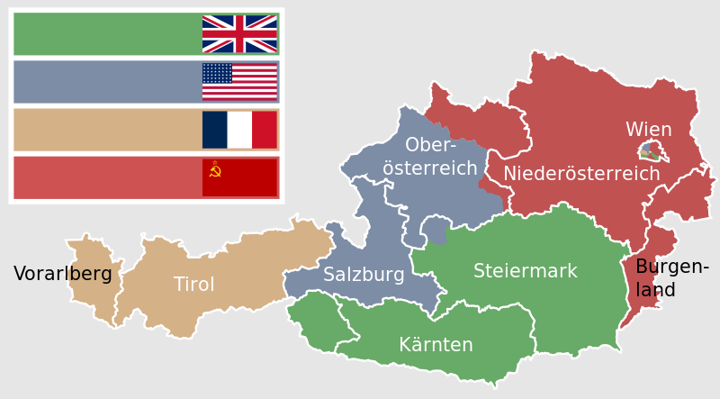
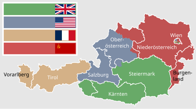
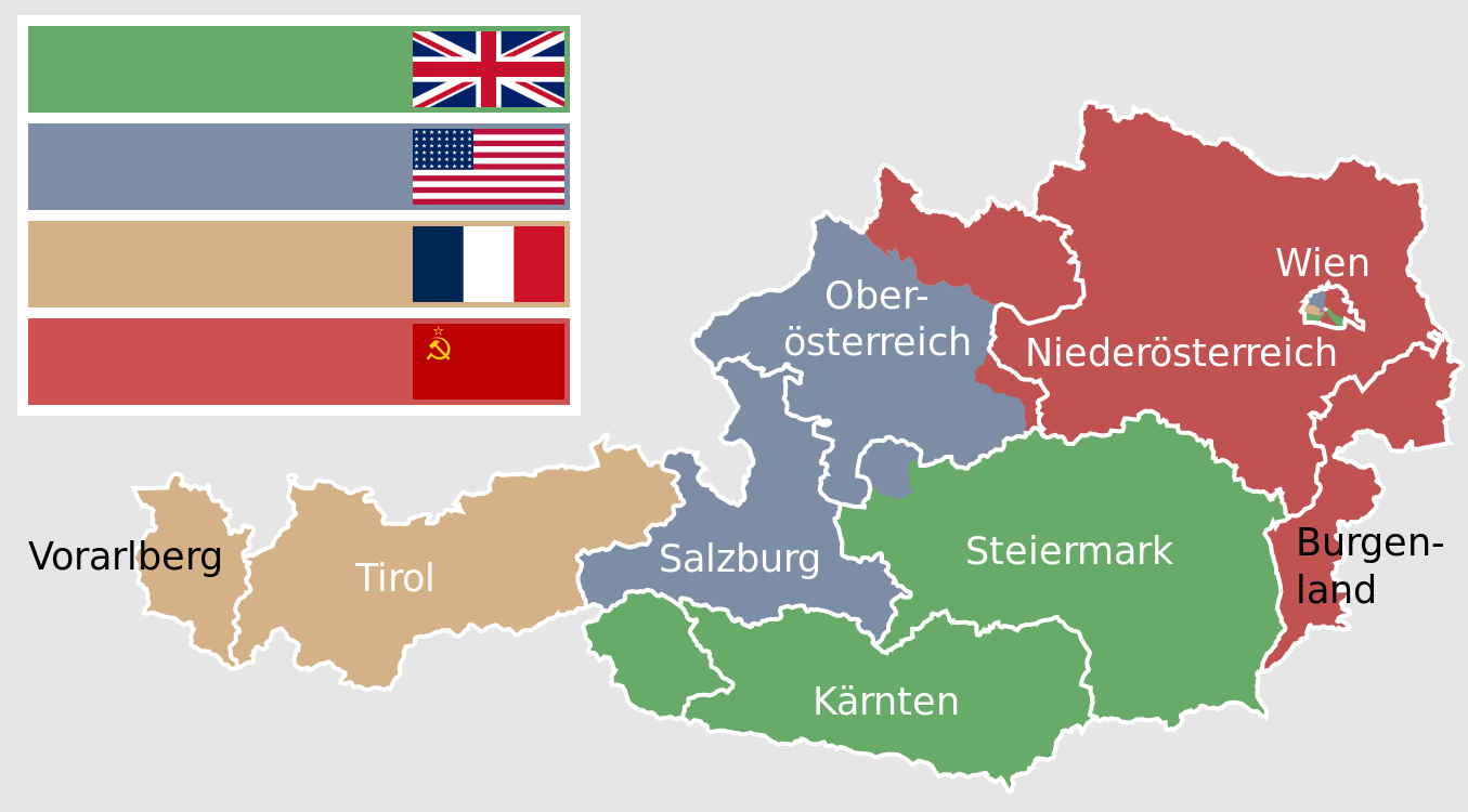
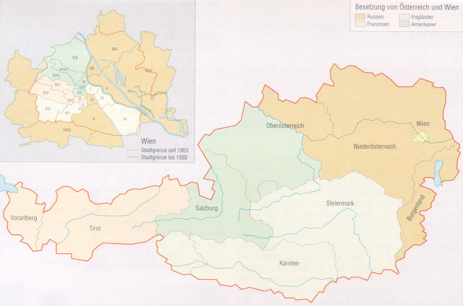
Deutsch: Karte der alliierten Besatzungszonen in Österreich von 1945 bis 1955. Die Grenzen der sowjetischen Zone Wiens entsprechen dem Stand von 1937, alle danach hinzugefügten Flächen zählen besatzungsrechtlich zu Niederösterreich.
Der blau gefärbte Teil innerhalb der Grenze im Nordwesten der Steiermark entspricht dem Übergang des Ausseer Landes zur Steiermark am 1. Juli 1948 und damit in die britische Zone. Die Kartenfärbung stellt den Stand von 1945 dar. English: Map of the allied occupation zones in Austria from 1945 to 1955. The borders of the soviet zone of Vienna are according to the state of the year 1937, every area added aftermath is counted to Lower Austria. |
| तारीख | |
| स्रोत |
recreation of Austria 1945-55.png using: |
| लेखक |
|
| Other versions |
Austria 1945-55.png Austria 1945-55.svg |
| SVG genesis |
.svg)
.svg)
.svg)

|
This image shows a flag, a coat of arms, a seal or some other official insignia. The use of such symbols is restricted in many countries. These restrictions are independent of the copyright status. |
लाइसेंसिंग
I, the copyright holder of this work, hereby publish it under the following licenses:

|
जीएनयू फ्री डाकुमेंटेशन लाइसेंस, वर्जन 1.2 या फिर कौनो भी बाद के प्रकाशित फ्री साफ्टवेयर फाउंडेशन लाइसेंस के शर्त के तहत, एह डाकुमेंट के नकल करे, बितरण करे आ/भा बदलाव करे के परमीशन दिहल गइल बा; एह में इनवैरिएंट खंड सभ नइखे शामिल, मुखपृष्ट के पाठ नइखे शामिल, आ बैक-कभर के पाठ नइखे शामिल। लाइसेंस के एगो प्रति जीएनयू फ्री डाकुमेंटेशन लाइसेंस नाँव के खंड में दिहल गइल बा। |
This file is licensed under the Creative Commons Attribution-Share Alike 3.0 Unported, 2.5 Generic, 2.0 Generic and 1.0 Generic license.
- आप फ्री बानी:
- साझा करे खातिर – रचना के नकल करे, बाँटे आ दुसरी जगह भेजे खातिर
- रीमिक्स करे खातिर – काम के अपनी हिसाब से बनावे खातिर
- नीचे दिहल कारणन की तहत:
- एट्रीब्यूशन – लाइसेंस के कड़ी दे के उचित श्रेय (क्रेडिट) दिहल जरूरी बा आ अगर कौनों बदलाव कइल गइल बा तब ओहू के बतावल जाए के चाहीं। आप ई काम कौनों उचित तरीका से क सकत बानी, बाकी ई न झलके के चाहीं की जेकरा लगे लाइसेंस बा ऊ राउर चाहे राउर काम के समर्थन करत बाटे या सही बतावत बा।
- शेयर अलाइक (share alike) – अगर आप एह सामग्री के आधार बना के कुछ रिमिक्स करत बानी, रूप बदलाव करत बानी, चाहे कुछ जोड़ के सामग्री के बढ़ावत बानी, आपके आपन योगदान ठीक एही या कंपेटिबल लाइसेंस जइसन कि ओरिजनल बाटे, के तहत होखे के चाहीं।
रउआँ अपनी जरूरत के लाइसेंस बीछ सकत बानीं।
फाइल के इतिहास
ओ समय ई फाइल कइसन लउके ई देखे खातिर कौनों तारीख/समय पर क्लिक करीं।
| तारीख/समय | चिप्पी रूप | डाइमेंशन | प्रयोगकर्ता | टिप्पणी | |
|---|---|---|---|---|---|
| वर्तमान | 16:33, 14 फरवरी 2023 | | 1,355 × 750 (167 KB) | Kematen | östlich der Enns sowj. |
| 11:23, 28 अक्टूबर 2020 |  | 1,355 × 750 (164 KB) | Hanzlan | corrected flags (American flag 48 stars/darke blue in French flag) and added name of Vienna | |
| 19:20, 27 अक्टूबर 2020 |  | 1,355 × 750 (153 KB) | Hanzlan | all flags same size, corrected the name of Vorarlberg | |
| 22:11, 19 जुलाई 2015 |  | 1,355 × 750 (148 KB) | Master Uegly | Borders of Vienna changed because soviet occupied areas which were added to Greater Vienna in 1938 were counted to Lower Austria. | |
| 21:31, 19 जुलाई 2015 |  | 1,355 × 750 (154 KB) | Master Uegly | {{Information |Description={{de|Karte der alliierten Besatzungszonen in Österreich von 1945 bis 1955}} {{en|Map of the allied occupation zones in Austria from 1945 to 1955}} |Source=recreation of {{f|Austria 1945-55.png}} using: * [http://www.aeiou.at... |
फाइल के उपयोग
फाइल के इस्तेमाल पन्ना करत बा:
बैस्विक फाइल उपयोग
नीचे दिहल अउरी विकिसभ पर एह फाइल के इस्तेमाल हो रहल बा:
- af.wikipedia.org पर इस्तेमाल
- ar.wikipedia.org पर इस्तेमाल
- bg.wikipedia.org पर इस्तेमाल
- ca.wikipedia.org पर इस्तेमाल
- cs.wikipedia.org पर इस्तेमाल
- da.wikipedia.org पर इस्तेमाल
- de.wikipedia.org पर इस्तेमाल
- de.wikibooks.org पर इस्तेमाल
- en.wikipedia.org पर इस्तेमाल
- et.wikipedia.org पर इस्तेमाल
- eu.wikipedia.org पर इस्तेमाल
- fa.wikipedia.org पर इस्तेमाल
- fr.wikipedia.org पर इस्तेमाल
- hu.wikipedia.org पर इस्तेमाल
- ja.wikipedia.org पर इस्तेमाल
- ka.wikipedia.org पर इस्तेमाल
- ko.wikipedia.org पर इस्तेमाल
- nl.wikipedia.org पर इस्तेमाल
- pnb.wikipedia.org पर इस्तेमाल
- pt.wikipedia.org पर इस्तेमाल
- ru.wikipedia.org पर इस्तेमाल
- sk.wikipedia.org पर इस्तेमाल
- th.wikipedia.org पर इस्तेमाल
- uk.wikipedia.org पर इस्तेमाल
- ur.wikipedia.org पर इस्तेमाल
- www.wikidata.org पर इस्तेमाल
- zh.wikipedia.org पर इस्तेमाल