सेंट लॉरेंस नदी: रिवीजन सभ के बीचा में अंतर
Content deleted Content added
छो सुधार |
+ ज्ञानसंदूक |
||
| लाइन 1: | लाइन 1: | ||
{{Geobox|River|category_hide=yes |
|||
<!-- *** Heading *** --> |
|||
| name = Saint Lawrence River |
|||
| other_name = ''Fleuve Saint-Laurent'' |
|||
| other_name1 = ''Fleuve St-Laurent'' |
|||
| other_name2 = St-Lawrence River |
|||
| other_name3 = St-Laurent River |
|||
<!-- *** Image *** ---> |
|||
| image = Saint Lawrence seaway.jpg |
|||
| image_size = |
|||
| image_caption = Saint Lawrence River near [[Alexandria Bay, New York|Alexandria Bay]] |
|||
| image_alt = |
|||
<!-- *** Name *** --> |
|||
| etymology = [[Lawrence of Rome|Saint Lawrence of Rome]] |
|||
| nickname = |
|||
<!-- *** Map section *** --> |
|||
| map = Grlakes lawrence map.png |
|||
| map_caption = Map of the Saint Lawrence/Great Lakes Watershed |
|||
<!-- General section *** --> |
|||
| country = Canada |
|||
| country1 = United States |
|||
| state = Ontario |
|||
| state1 = Quebec |
|||
| state_type = Provinces |
|||
| region_type = State |
|||
| region = [[New York (state)|New York]] |
|||
| length = 500 |
|||
| length_round = -1 |
|||
| length_note = Excluding the estuary. Ca. 1200 km if included. |
|||
| watershed = 1344200 |
|||
| watershed_round = -2 |
|||
| watershed_note = <ref name=Atlas>Natural Resources Canada, Atlas of Canada - [http://atlas.nrcan.gc.ca/site/english/learningresources/facts/rivers.html Rivers]</ref> |
|||
| discharge_location = below the [[Saguenay River]] |
|||
| discharge = 16800 |
|||
| discharge_round = -4 |
|||
| discharge_note = <ref name="BenkeCushing2005"/> |
|||
| discharge_max_note = |
|||
| discharge_max = |
|||
| discharge_min_note = |
|||
| discharge_min = |
|||
| discharge1_location = |
|||
| discharge1 = |
|||
<!-- *** Source *** --> |
|||
| source = Lake Ontario |
|||
| source_location = [[Kingston, Ontario]] / [[Cape Vincent, New York]] |
|||
| source_district = |
|||
| source_state = |
|||
| source_country = |
|||
| source_elevation = 74.7 |
|||
| source_coordinates = {{coord|44|06|N|76|24|W|display=inline}} |
|||
| mouth_name = [[Gulf of St. Lawrence]] / [[Atlantic Ocean]] |
|||
| mouth_location = |
|||
| mouth_region = |
|||
| mouth_state = Quebec |
|||
| mouth_country = Canada |
|||
| mouth_elevation = 0 |
|||
| capital_coordinates = |
|||
| mouth_coordinates = {{coord|49|30|N|64|30|W|display=inline,title}} |
|||
}} |
|||
'''सेंट लॉरेंस नदी''' ({{Lang-en|Saint Lawrence River}}) [[उत्तर अमेरिका महादीप]] के एक ठो प्रमुख नदी बाटे। |
'''सेंट लॉरेंस नदी''' ({{Lang-en|Saint Lawrence River}}) [[उत्तर अमेरिका महादीप]] के एक ठो प्रमुख नदी बाटे। |
||
07:35, 16 अगस्त 2018 तक ले भइल बदलाव
| Saint Lawrence River | |
| Fleuve Saint-Laurent, Fleuve St-Laurent, St-Lawrence River, St-Laurent River | |
Saint Lawrence River near Alexandria Bay
| |
| नाँवउत्पत्ती: Saint Lawrence of Rome | |
| देस | Canada, United States |
|---|---|
| Provinces | Ontario, Quebec |
| State | New York |
| उदगम | Lake Ontario |
| - लोकेशन | Kingston, Ontario / Cape Vincent, New York |
| - ऊँचाई | 74.7 मी (245 फीट) |
| - निर्देशांक | 44°06′N 76°24′W / 44.100°N 76.400°W |
| मुहाना | Gulf of St. Lawrence / Atlantic Ocean |
| - ऊँचाई | 0 मी (0 फीट) |
| - निर्देशांक | 49°30′N 64°30′W / 49.500°N 64.500°Wनिर्देशांक: 49°30′N 64°30′W / 49.500°N 64.500°W |
| लंबाई | 500 किमी (310 मील) Excluding the estuary. Ca. 1200 km if included. |
| थाला | 1,344,200 किमी2 (519,000 वर्ग मील) [1] |
| जलनिकास | for below the Saguenay River |
| - औसत | 16,800 m3/s (590,000 cu ft/s) [2] |
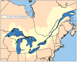
Map of the Saint Lawrence/Great Lakes Watershed
| |
सेंट लॉरेंस नदी (अंग्रेजी: Saint Lawrence River) उत्तर अमेरिका महादीप के एक ठो प्रमुख नदी बाटे।
| ई लेख कौनो नदी के बारे में एगो आधार बाटे। जानकारी जोड़ के एकरा के बढ़ावे में विकिपीडिया के मदद करीं। |


