
चित्र:Zhujiangrivermap.png
ए नमूना के साइज: 800 × 542 पिक्सेल. अउरी रिजोल्यूशन: 320 × 217 पिक्सेल | 640 × 433 पिक्सेल | 988 × 669 पिक्सेल.
ओरिजनल फाइल (988 × 669 पिक्सेल, फाइल साइज: 308 KB, MIME टाइप: image/png)
सारांश
| बिबरण |
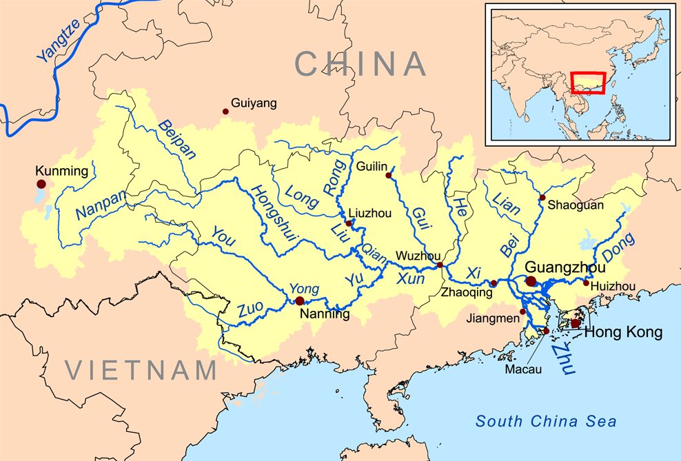
English: Map of the tributaries of the Pearl River, and the Pearl River Basin (watershed/drainage basin) in yellow.
|
| तारीख | |
| स्रोत | आपन रचना |
| लेखक | Kmusser |
| Other versions | Estonian |
लाइसेंसिंग
I, the copyright holder of this work, hereby publish it under the following license:
ई फाइल Creative Commons Attribution-Share Alike 3.0 Unported लाइसेंस की तहत लाइसेंसी बा।
- आप फ्री बानी:
- साझा करे खातिर – रचना के नकल करे, बाँटे आ दुसरी जगह भेजे खातिर
- रीमिक्स करे खातिर – काम के अपनी हिसाब से बनावे खातिर
- नीचे दिहल कारणन की तहत:
- एट्रीब्यूशन – लाइसेंस के कड़ी दे के उचित श्रेय (क्रेडिट) दिहल जरूरी बा आ अगर कौनों बदलाव कइल गइल बा तब ओहू के बतावल जाए के चाहीं। आप ई काम कौनों उचित तरीका से क सकत बानी, बाकी ई न झलके के चाहीं की जेकरा लगे लाइसेंस बा ऊ राउर चाहे राउर काम के समर्थन करत बाटे या सही बतावत बा।
- शेयर अलाइक (share alike) – अगर आप एह सामग्री के आधार बना के कुछ रिमिक्स करत बानी, रूप बदलाव करत बानी, चाहे कुछ जोड़ के सामग्री के बढ़ावत बानी, आपके आपन योगदान ठीक एही या कंपेटिबल लाइसेंस जइसन कि ओरिजनल बाटे, के तहत होखे के चाहीं।
फाइल के इतिहास
ओ समय ई फाइल कइसन लउके ई देखे खातिर कौनों तारीख/समय पर क्लिक करीं।
| तारीख/समय | चिप्पी रूप | डाइमेंशन | प्रयोगकर्ता | टिप्पणी | |
|---|---|---|---|---|---|
| वर्तमान | 13:59, 21 दिसंबर 2015 | | 988 × 669 (308 KB) | Ras67 | cropped |
| 20:09, 19 नवंबर 2008 |  | 1,000 × 681 (346 KB) | Kmusser | {{Information |Description=This is a map of the Pearl River drainage basin. |Source=Own work using http://www.maproom.psu.edu/dcw/ Digital Chart of the World and [[http://edc.usgs.gov/products/elevation/gtopo30/gtopo30.html |
फाइल के उपयोग
फाइल के इस्तेमाल पन्ना करत बा:
बैस्विक फाइल उपयोग
नीचे दिहल अउरी विकिसभ पर एह फाइल के इस्तेमाल हो रहल बा:
- af.wikipedia.org पर इस्तेमाल
- ar.wikipedia.org पर इस्तेमाल
- arz.wikipedia.org पर इस्तेमाल
- ast.wikipedia.org पर इस्तेमाल
- azb.wikipedia.org पर इस्तेमाल
- az.wikipedia.org पर इस्तेमाल
- ba.wikipedia.org पर इस्तेमाल
- be.wikipedia.org पर इस्तेमाल
- bg.wikipedia.org पर इस्तेमाल
- bn.wikipedia.org पर इस्तेमाल
- ceb.wikipedia.org पर इस्तेमाल
- cs.wikipedia.org पर इस्तेमाल
- da.wikipedia.org पर इस्तेमाल
- de.wikipedia.org पर इस्तेमाल
- en.wikipedia.org पर इस्तेमाल
एह फाइल के अउरी बैस्विक इस्तेमाल देखीं