
चित्र:Trópico de Cáncer en México - Carretera 83 (Vía Corta) Zaragoza-Victoria, Km 27+800.jpg

ए नमूना के साइज: 800 × 600 पिक्सेल. अउरी रिजोल्यूशन: 320 × 240 पिक्सेल | 640 × 480 पिक्सेल | 1,024 × 768 पिक्सेल | 1,280 × 960 पिक्सेल | 2,560 × 1,920 पिक्सेल | 3,264 × 2,448 पिक्सेल.
ओरिजनल फाइल (3,264 × 2,448 पिक्सेल, फाइल साइज: 2.33 MB, MIME टाइप: image/jpeg)
_Zaragoza-Victoria,_Km_27%2B800.jpg)
सारांश
| बिबरण |
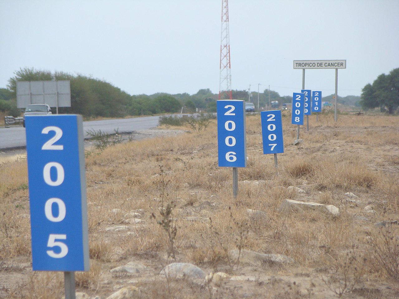
Español: De todos los cruces del Trópico de Cáncer con las carreteras federales mexicanas, éste es el único lugar donde la línea está marcada con absoluta precisión y además se puede visualizar el desplazamiento anual entre los años 2005 y 2010.
English: Of all crossings of the Tropic of Cancer with Mexican federal highways, this is the only place where the line is marked with precision and history of the annual movement since 2005.
Publicada originalmente en Trópico en movimiento (Archived 22 May 2011 at the Wayback Machine) |
| तारीख | |
| स्रोत | आपन रचना |
| लेखक | Roberto González |
लाइसेंसिंग
I, the copyright holder of this work, hereby publish it under the following licenses:

|
जीएनयू फ्री डाकुमेंटेशन लाइसेंस, वर्जन 1.2 या फिर कौनो भी बाद के प्रकाशित फ्री साफ्टवेयर फाउंडेशन लाइसेंस के शर्त के तहत, एह डाकुमेंट के नकल करे, बितरण करे आ/भा बदलाव करे के परमीशन दिहल गइल बा; एह में इनवैरिएंट खंड सभ नइखे शामिल, मुखपृष्ट के पाठ नइखे शामिल, आ बैक-कभर के पाठ नइखे शामिल। लाइसेंस के एगो प्रति जीएनयू फ्री डाकुमेंटेशन लाइसेंस नाँव के खंड में दिहल गइल बा। |
This file is licensed under the Creative Commons Attribution-Share Alike 4.0 International, 3.0 Unported, 2.5 Generic, 2.0 Generic and 1.0 Generic license.
- आप फ्री बानी:
- साझा करे खातिर – रचना के नकल करे, बाँटे आ दुसरी जगह भेजे खातिर
- रीमिक्स करे खातिर – काम के अपनी हिसाब से बनावे खातिर
- नीचे दिहल कारणन की तहत:
- एट्रीब्यूशन – लाइसेंस के कड़ी दे के उचित श्रेय (क्रेडिट) दिहल जरूरी बा आ अगर कौनों बदलाव कइल गइल बा तब ओहू के बतावल जाए के चाहीं। आप ई काम कौनों उचित तरीका से क सकत बानी, बाकी ई न झलके के चाहीं की जेकरा लगे लाइसेंस बा ऊ राउर चाहे राउर काम के समर्थन करत बाटे या सही बतावत बा।
- शेयर अलाइक (share alike) – अगर आप एह सामग्री के आधार बना के कुछ रिमिक्स करत बानी, रूप बदलाव करत बानी, चाहे कुछ जोड़ के सामग्री के बढ़ावत बानी, आपके आपन योगदान ठीक एही या कंपेटिबल लाइसेंस जइसन कि ओरिजनल बाटे, के तहत होखे के चाहीं।
रउआँ अपनी जरूरत के लाइसेंस बीछ सकत बानीं।
फाइल के इतिहास
ओ समय ई फाइल कइसन लउके ई देखे खातिर कौनों तारीख/समय पर क्लिक करीं।
| तारीख/समय | चिप्पी रूप | डाइमेंशन | प्रयोगकर्ता | टिप्पणी | |
|---|---|---|---|---|---|
| वर्तमान | 04:47, 1 फरवरी 2011 | | 3,264 × 2,448 (2.33 MB) | Wkboonec | {{Information |Description ={{es|1=De todos los cruces del Trópico de Cáncer con las carreteras federales mexicanas, éste es el único lugar donde la imaginaria línea está marcada con absoluta precisión y además se puede visualizar el desplazami |
फाइल के उपयोग
फाइल के इस्तेमाल पन्ना करत बा:
बैस्विक फाइल उपयोग
नीचे दिहल अउरी विकिसभ पर एह फाइल के इस्तेमाल हो रहल बा:
- ast.wikipedia.org पर इस्तेमाल
- ba.wikipedia.org पर इस्तेमाल
- bs.wikipedia.org पर इस्तेमाल
- ca.wikipedia.org पर इस्तेमाल
- de.wikipedia.org पर इस्तेमाल
- en.wikipedia.org पर इस्तेमाल
- es.wikipedia.org पर इस्तेमाल
- he.wikipedia.org पर इस्तेमाल
- ilo.wikipedia.org पर इस्तेमाल
- it.wikipedia.org पर इस्तेमाल
- ja.wikipedia.org पर इस्तेमाल
- mk.wikipedia.org पर इस्तेमाल
- ml.wikipedia.org पर इस्तेमाल
- ms.wikipedia.org पर इस्तेमाल
- no.wikipedia.org पर इस्तेमाल
- pl.wikipedia.org पर इस्तेमाल
- rue.wikipedia.org पर इस्तेमाल
- ru.wikipedia.org पर इस्तेमाल
- sr.wikipedia.org पर इस्तेमाल
- sv.wikipedia.org पर इस्तेमाल
- ta.wikipedia.org पर इस्तेमाल
- tr.wikipedia.org पर इस्तेमाल
- www.wikidata.org पर इस्तेमाल
_Zaragoza-Victoria,_Km_27%2B800.jpg)