
चित्र:Syrdaryamap.png
ए नमूना के साइज: 719 × 600 पिक्सेल. अउरी रिजोल्यूशन: 288 × 240 पिक्सेल | 576 × 480 पिक्सेल | 820 × 684 पिक्सेल.
ओरिजनल फाइल (820 × 684 पिक्सेल, फाइल साइज: 936 KB, MIME टाइप: image/png)
सारांश

|
This map image could be re-created using vector graphics as an SVG file. This has several advantages; see Commons:Media for cleanup for more information. If an SVG form of this image is available, please upload it and afterwards replace this template with
{{vector version available|new image name}}.
It is recommended to name the SVG file “Syrdaryamap.svg”—then the template Vector version available (or Vva) does not need the new image name parameter. |
| बिबरण |
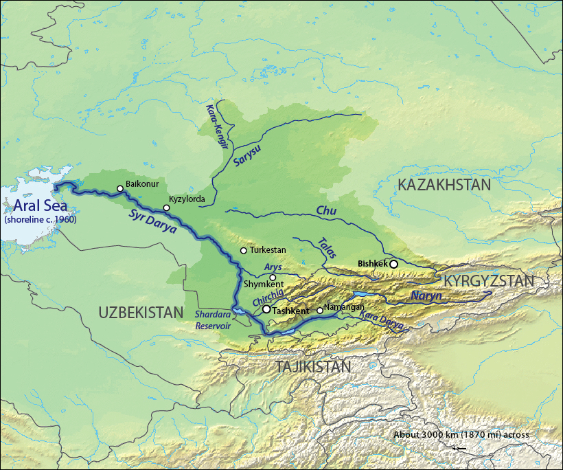
English: Map of the Syr Darya Basin watershed, of the Syr Darya and Chu Rivers — in Central Asia.
Қазақша: Сырдария
Татарча / tatarça: Сырдәрья |
| तारीख | to 06 |
| स्रोत | Background and river course data from http://www2.demis.nl/mapserver/mapper.asp |
| लेखक | Background layer attributed to DEMIS Mapserver, map created by Shannon1 |
| परमीशन (एह फाइल के दुबारा इस्तेमाल) |
Map created from DEMIS Mapserver, which are public domain. |
| Other versions |
Derivative works of this file: |
लाइसेंसिंग
I, the copyright holder of this work, hereby publish it under the following licenses:

|
जीएनयू फ्री डाकुमेंटेशन लाइसेंस, वर्जन 1.2 या फिर कौनो भी बाद के प्रकाशित फ्री साफ्टवेयर फाउंडेशन लाइसेंस के शर्त के तहत, एह डाकुमेंट के नकल करे, बितरण करे आ/भा बदलाव करे के परमीशन दिहल गइल बा; एह में इनवैरिएंट खंड सभ नइखे शामिल, मुखपृष्ट के पाठ नइखे शामिल, आ बैक-कभर के पाठ नइखे शामिल। लाइसेंस के एगो प्रति जीएनयू फ्री डाकुमेंटेशन लाइसेंस नाँव के खंड में दिहल गइल बा। |
This file is licensed under the Creative Commons Attribution-Share Alike 4.0 International, 3.0 Unported, 2.5 Generic, 2.0 Generic and 1.0 Generic license.
- आप फ्री बानी:
- साझा करे खातिर – रचना के नकल करे, बाँटे आ दुसरी जगह भेजे खातिर
- रीमिक्स करे खातिर – काम के अपनी हिसाब से बनावे खातिर
- नीचे दिहल कारणन की तहत:
- एट्रीब्यूशन – लाइसेंस के कड़ी दे के उचित श्रेय (क्रेडिट) दिहल जरूरी बा आ अगर कौनों बदलाव कइल गइल बा तब ओहू के बतावल जाए के चाहीं। आप ई काम कौनों उचित तरीका से क सकत बानी, बाकी ई न झलके के चाहीं की जेकरा लगे लाइसेंस बा ऊ राउर चाहे राउर काम के समर्थन करत बाटे या सही बतावत बा।
- शेयर अलाइक (share alike) – अगर आप एह सामग्री के आधार बना के कुछ रिमिक्स करत बानी, रूप बदलाव करत बानी, चाहे कुछ जोड़ के सामग्री के बढ़ावत बानी, आपके आपन योगदान ठीक एही या कंपेटिबल लाइसेंस जइसन कि ओरिजनल बाटे, के तहत होखे के चाहीं।
रउआँ अपनी जरूरत के लाइसेंस बीछ सकत बानीं।
फाइल के इतिहास
ओ समय ई फाइल कइसन लउके ई देखे खातिर कौनों तारीख/समय पर क्लिक करीं।
| तारीख/समय | चिप्पी रूप | डाइमेंशन | प्रयोगकर्ता | टिप्पणी | |
|---|---|---|---|---|---|
| वर्तमान | 03:11, 18 अक्टूबर 2013 | | 820 × 684 (936 KB) | Shannon1 | redrew and fixed watershed boundary |
| 09:21, 8 जनवरी 2011 |  | 1,101 × 866 (1.65 MB) | Sibom | chu | |
| 09:20, 8 जनवरी 2011 |  | 1,101 × 866 (1.65 MB) | Sibom | чу | |
| 03:04, 7 फरवरी 2010 |  | 1,101 × 866 (1.51 MB) | Shannon1 | {{Information |Description={{en|1=Map of the watershed of the Syr Darya in Central Asia, that drains to the Aral Sea.}} |Source=Background and river course data from http://www2.demis.nl/mapserver/mapper.asp |Author=Background layer attributed to DEMIS M |
फाइल के उपयोग
फाइल के इस्तेमाल पन्ना करत बा:
बैस्विक फाइल उपयोग
नीचे दिहल अउरी विकिसभ पर एह फाइल के इस्तेमाल हो रहल बा:
- af.wikipedia.org पर इस्तेमाल
- ar.wikipedia.org पर इस्तेमाल
- ast.wikipedia.org पर इस्तेमाल
- bg.wikipedia.org पर इस्तेमाल
- bn.wikipedia.org पर इस्तेमाल
- cs.wikipedia.org पर इस्तेमाल
- cv.wikipedia.org पर इस्तेमाल
- da.wikipedia.org पर इस्तेमाल
- de.wikipedia.org पर इस्तेमाल
- en.wikipedia.org पर इस्तेमाल
- es.wikipedia.org पर इस्तेमाल
- et.wikipedia.org पर इस्तेमाल
- fi.wikipedia.org पर इस्तेमाल
- fr.wikipedia.org पर इस्तेमाल
- he.wikipedia.org पर इस्तेमाल
- hi.wikipedia.org पर इस्तेमाल
- hr.wikipedia.org पर इस्तेमाल
- hu.wikipedia.org पर इस्तेमाल
- hy.wikipedia.org पर इस्तेमाल
- id.wikipedia.org पर इस्तेमाल
- incubator.wikimedia.org पर इस्तेमाल
एह फाइल के अउरी बैस्विक इस्तेमाल देखीं