
चित्र:NepalPanchtharDistrictmap.png

ओरिजनल फाइल (2,479 × 3,508 पिक्सेल, फाइल साइज: 376 KB, MIME टाइप: image/png)
सारांश
| बिबरण |
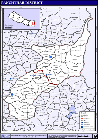
English: Map displaying Village Development Committees in Panchthar District, Nepal |
| तारीख | |
| स्रोत | http://www.un.org.np/maps/district-maps/eastern/Panchthar.pdf |
| लेखक | United Nations |
लाइसेंसिंग
| This image is a map derived from a United Nations map.
Unless stated otherwise, UN maps are to be considered in the public domain. This applies worldwide. UN maps are, in principle, open source material and you can use them in your work or for making your own map. UN requests however that you delete the UN name, logo and reference number upon any modification to the map. Content of your map will be your responsibility. You can state in your publication, if you wish, something like: based on UN map … (map name, map number, revision number and date). See: Geospatial Information Section. And: Geospatial, location data for a better world. |
 |
फाइल के इतिहास
ओ समय ई फाइल कइसन लउके ई देखे खातिर कौनों तारीख/समय पर क्लिक करीं।
| तारीख/समय | चिप्पी रूप | डाइमेंशन | प्रयोगकर्ता | टिप्पणी | |
|---|---|---|---|---|---|
| वर्तमान | 13:54, 13 नवंबर 2008 | | 2,479 × 3,508 (376 KB) | Sadalmelik | == Summary == {{Information |Description={{en|1=Map displaying Village Development Committees in Panchthar District, Nepal}} |Source=http://www.un.org.np/maps/district-maps/eastern/Panchthar.pdf |Date=January 3, 2008 |Author=United Nations |Permissio |
फाइल के उपयोग
कौनों पन्ना नइखे जवन ए फाइल के इस्तेमाल करत होखे।
बैस्विक फाइल उपयोग
नीचे दिहल अउरी विकिसभ पर एह फाइल के इस्तेमाल हो रहल बा:
- bn.wikipedia.org पर इस्तेमाल
- bpy.wikipedia.org पर इस्तेमाल
- da.wikipedia.org पर इस्तेमाल
- de.wikipedia.org पर इस्तेमाल
- en.wikipedia.org पर इस्तेमाल
- fi.wikipedia.org पर इस्तेमाल
- hif.wikipedia.org पर इस्तेमाल
- mai.wikipedia.org पर इस्तेमाल
- पाँचथर जिला
- आकृति:पाँचथर जिलाक नगरपालिका तथा गाविससभ
- अमबरपुर
- आङना
- आङसराङ्ग
- आरुवोटे
- ईम्बुङ्ग
- एकतिन
- ओयाम
- ओलेने
- कुरुम्बा
- चिलिङदिन
- च्याङथापु
- थर्पु
- दुर्दिम्बा
- नवमीडाँडा
- नागी
- नाङ्गिन
- पञ्चमी, पाँचथर
- पौवा सर्ताप
- प्राङवुङ्ग
- फलैंचा, पाँचथर
- फाक्तेप
- भारपा
- माङजाबुङ्ग
- मेमेङ्ग
- मौवा, पाँचथर
- याङनाम
- यासोक
- रवि
- रानी गाउँ
- रानीटार
- लिम्बा
- लुङरूपा
- लुम्फावुङ्ग
- सराङडाँडा
- सिदिन
- सुभाङ्ग
- स्याबरुम्बा
- हाङगुम
- फिदिम नगरपालिका
- आकृति:पाँचथर जिलाक नगरपालिका आ गाविससभ
एह फाइल के अउरी बैस्विक इस्तेमाल देखीं