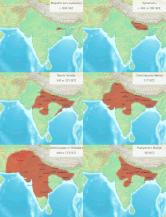
चित्र:Magadha Expansion 1.gif
Magadha_Expansion_1.gif (680 × 593 पिक्सेल, फाइल साइज: 2.78 MB, MIME टाइप: image/gif, लूप्ड, 12 फ्रेम सभ, 15 s)
फाइल के इतिहास
ओ समय ई फाइल कइसन लउके ई देखे खातिर कौनों तारीख/समय पर क्लिक करीं।
| तारीख/समय | चिप्पी रूप | डाइमेंशन | प्रयोगकर्ता | टिप्पणी | |
|---|---|---|---|---|---|
| वर्तमान | 05:14, 25 दिसंबर 2023 |  | 680 × 593 (2.78 MB) | Antiidistorian | Reverted to version as of 07:02, 9 July 2018 (UTC) . This GIF is widely used in the name of Schwartzberg map boundaries. However, it is noteworthy that Schwartzberg accurately incorporated Gedrosia in his map. Please verify: https://dsal.uchicago.edu/reference/schwartzberg/pager.html?object=055. If you intend to make alterations, kindly update the captions on the Gujarati , English and other wiki pages first. Then you, feel free to utilize it as desired. Otherwise, it may mislead individual... |
| 05:51, 16 दिसंबर 2023 |  | 680 × 593 (2.19 MB) | Avantiputra7 | Reverted to version as of 22:58, 29 April 2020 (UTC) | |
| 14:34, 14 अक्टूबर 2023 |  | 680 × 593 (2.25 MB) | Rajanyatalk | Reverted to version as of 07:20, 9 July 2018 (UTC) | |
| 22:58, 29 अप्रैल 2020 |  | 680 × 593 (2.19 MB) | Avantiputra7 | small fixes | |
| 07:20, 9 जुलाई 2018 |  | 680 × 593 (2.25 MB) | Avantiputra7 | slowed down for readability | |
| 07:02, 9 जुलाई 2018 |  | 680 × 593 (2.78 MB) | Avantiputra7 | User created page with UploadWizard |
फाइल के उपयोग
कौनों पन्ना नइखे जवन ए फाइल के इस्तेमाल करत होखे।
बैस्विक फाइल उपयोग
नीचे दिहल अउरी विकिसभ पर एह फाइल के इस्तेमाल हो रहल बा:
- bn.wikipedia.org पर इस्तेमाल
- ceb.wikipedia.org पर इस्तेमाल
- cs.wikipedia.org पर इस्तेमाल
- en.wikipedia.org पर इस्तेमाल
- fa.wikipedia.org पर इस्तेमाल
- fr.wikipedia.org पर इस्तेमाल
- gu.wikipedia.org पर इस्तेमाल
- hi.wikipedia.org पर इस्तेमाल
- hy.wikipedia.org पर इस्तेमाल
- id.wikipedia.org पर इस्तेमाल
- it.wikipedia.org पर इस्तेमाल
- ja.wikipedia.org पर इस्तेमाल
- ko.wikipedia.org पर इस्तेमाल
- ms.wikipedia.org पर इस्तेमाल
- pa.wikipedia.org पर इस्तेमाल
- pnb.wikipedia.org पर इस्तेमाल
- ta.wikipedia.org पर इस्तेमाल
- te.wikipedia.org पर इस्तेमाल
- ur.wikipedia.org पर इस्तेमाल
- zh.wikipedia.org पर इस्तेमाल

