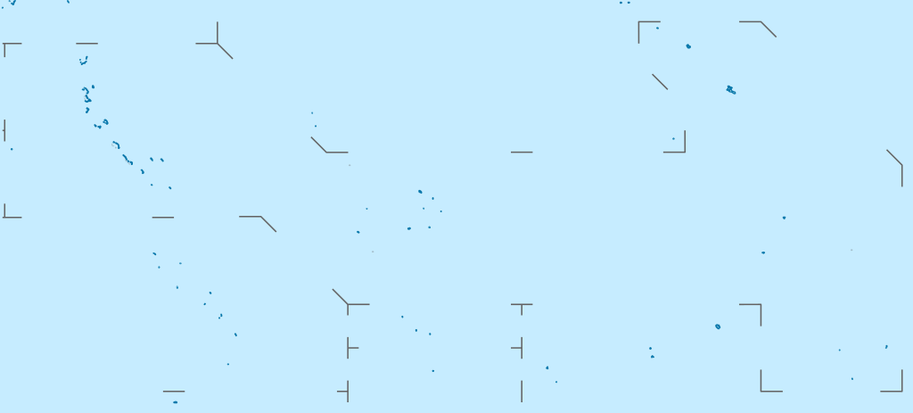
चित्र:Kiribati location map.svg

Page contents not supported in other languages.
विकिपीडिया से

ओरिजनल फाइल(एसवीजी फाइल, नॉमिनली 1,488 x 673 पिक्सल, फाइल के आकार: 68 KB)

ई फाइल Wikimedia Commons से बा आ अउरी प्रोजेक्ट भी एकर इस्तेमाल कर सकत बाड़ें। एकर विवरण फाइल विवरण पन्ना नीचे देखावल गइल बा।

सारांश

बिबरण
Deutsch: Positionskarte von Kiribati

Quadratische Plattkarte. Geographische Begrenzung der Karte:

  • N: 6° N
  • S: 13° S
  • W: 169° O
  • O: 149° W
English: Location map of Kiribati

Equirectangular projection. Geographic limits of the map:

  • N: 6° N
  • S: 13° S
  • W: 169° E
  • E: 149° W
तारीख
स्रोत

आपन रचना, using

  • United States National Imagery and Mapping Agency data
लेखक NordNordWest
परमीशन
(एह फाइल के दुबारा इस्तेमाल)

I have published this file as author NordNordWest under the "CC-BY-SA-3.0-DE" in Wikipedia. This means that free, commercial usage outside of Wikipedia is permitted under the following licence terms:

Please send me a specimen copy or the URL of the website where the file is used.

Please write an email to nnwest[at]web.de if you

  • need my postal address for sending a specimen copy
  • have further questions about the terms of the licence

PS: In case of refusal of the above terms the author reserves the right to take legal action.

w:en:Creative Commons
एट्रीब्यूशन शेयर अलाइक (share alike)
This file is licensed under the Creative Commons Attribution-Share Alike 3.0 Germany license.
आप फ्री बानी:
  • साझा करे खातिर – रचना के नकल करे, बाँटे आ दुसरी जगह भेजे खातिर
  • रीमिक्स करे खातिर – काम के अपनी हिसाब से बनावे खातिर
नीचे दिहल कारणन की तहत:
  • एट्रीब्यूशन – लाइसेंस के कड़ी दे के उचित श्रेय (क्रेडिट) दिहल जरूरी बा आ अगर कौनों बदलाव कइल गइल बा तब ओहू के बतावल जाए के चाहीं। आप ई काम कौनों उचित तरीका से क सकत बानी, बाकी ई न झलके के चाहीं की जेकरा लगे लाइसेंस बा ऊ राउर चाहे राउर काम के समर्थन करत बाटे या सही बतावत बा।
  • शेयर अलाइक (share alike) – अगर आप एह सामग्री के आधार बना के कुछ रिमिक्स करत बानी, रूप बदलाव करत बानी, चाहे कुछ जोड़ के सामग्री के बढ़ावत बानी, आपके आपन योगदान ठीक एही या कंपेटिबल लाइसेंस जइसन कि ओरिजनल बाटे, के तहत होखे के चाहीं।
Other versions
Kartenwerkstatt
This map has been made or improved in the German Kartenwerkstatt (Map Lab). You can propose maps to improve as well.

Captions

Add a one-line explanation of what this file represents

Items portrayed in this file

depicts अंगरेजी

creator अंगरेजी

some value

author name string अंगरेजी: NordNordWest
Wikimedia username अंगरेजी: NordNordWest

copyright status अंगरेजी

copyrighted अंगरेजी

copyright license अंगरेजी

inception अंगरेजी

५ मार्च 2010

source of file अंगरेजी

original creation by uploader अंगरेजी

MIME type अंगरेजी

image/svg+xml

फाइल के इतिहास

ओ समय ई फाइल कइसन लउके ई देखे खातिर कौनों तारीख/समय पर क्लिक करीं।

तारीख/समयचिप्पी रूपडाइमेंशनप्रयोगकर्ताटिप्पणी
वर्तमान15:52, 23 फरवरी 202115:52, 23 फरवरी 2021 ले के संस्करण के चिप्पी रूप।1,488 × 673 (68 KB)NordNordWestReverted to version as of 09:54, 1 April 2010 (UTC), sorry, but this is not location map style
13:08, 23 फरवरी 202113:08, 23 फरवरी 2021 ले के संस्करण के चिप्पी रूप।1,488 × 673 (137 KB)Amitchell125borders made visible with minor corrections
09:54, 1 अप्रैल 201009:54, 1 अप्रैल 2010 ले के संस्करण के चिप्पी रूप।1,488 × 673 (68 KB)NordNordWestc
20:04, 5 मार्च 201020:04, 5 मार्च 2010 ले के संस्करण के चिप्पी रूप।1,488 × 673 (84 KB)NordNordWest== {{int:filedesc}} == {{Information |Description= {{de|Positionskarte von Kiribati}} Quadratische Plattkarte. Geographische Begrenzung der Karte: * N: 6° N * S: 13° S * W: 169° O * O: 149° W {{en|Location map of [[:en:Kiribati|Kiriba

फाइल के इस्तेमाल 2 पन्ना करत बाड़ें:

बैस्विक फाइल उपयोग

नीचे दिहल अउरी विकिसभ पर एह फाइल के इस्तेमाल हो रहल बा:

एह फाइल के अउरी बैस्विक इस्तेमाल देखीं

मेटाडाटा