
चित्र:Irma 2017-09-06 1745Z.jpg

ए नमूना के साइज: 459 × 599 पिक्सेल. अउरी रिजोल्यूशन: 184 × 240 पिक्सेल | 368 × 480 पिक्सेल | 588 × 768 पिक्सेल | 784 × 1,024 पिक्सेल | 1,569 × 2,048 पिक्सेल | 7,200 × 9,400 पिक्सेल.
ओरिजनल फाइल (7,200 × 9,400 पिक्सेल, फाइल साइज: 10.39 MB, MIME टाइप: image/jpeg)
सारांश
| बिबरण |
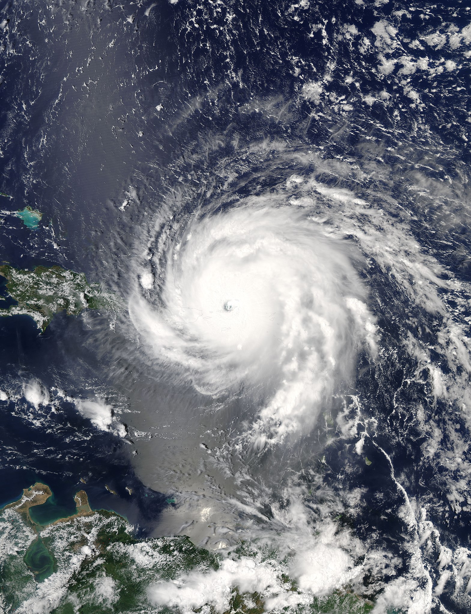
English: Hurricane Irma over the Virgin Islands at peak intensity on September 6, 2017 as the second most intense Atlantic hurricane on record in terms of sustained winds. |
| तारीख | |
| स्रोत | Rapid Response - LANCE |
| लेखक | MODIS image captured by NASA’s Aqua satellite |
| Camera location | | View this and other nearby images on: OpenStreetMap |
|---|
लाइसेंसिंग
| This file is in the public domain in the United States because it was solely created by NASA. NASA copyright policy states that "NASA material is not protected by copyright unless noted". (See Template:PD-USGov, NASA copyright policy page or JPL Image Use Policy.) | ||
 |
Warnings:
|
फाइल के इतिहास
ओ समय ई फाइल कइसन लउके ई देखे खातिर कौनों तारीख/समय पर क्लिक करीं।
| तारीख/समय | चिप्पी रूप | डाइमेंशन | प्रयोगकर्ता | टिप्पणी | |
|---|---|---|---|---|---|
| वर्तमान | 03:58, 5 फरवरी 2018 | | 7,200 × 9,400 (10.39 MB) | A1Cafel | 250m |
| 21:46, 6 सितंबर 2017 |  | 7,200 × 9,600 (18.71 MB) | Meow | User created page with UploadWizard |
फाइल के उपयोग
फाइल के इस्तेमाल पन्ना करत बा:
बैस्विक फाइल उपयोग
नीचे दिहल अउरी विकिसभ पर एह फाइल के इस्तेमाल हो रहल बा:
- ar.wikipedia.org पर इस्तेमाल
- bn.wikipedia.org पर इस्तेमाल
- cs.wikipedia.org पर इस्तेमाल
- da.wikipedia.org पर इस्तेमाल
- de.wikipedia.org पर इस्तेमाल
- de.wikinews.org पर इस्तेमाल
- en.wikipedia.org पर इस्तेमाल
- User:Wiki Feed Bot/test
- Wikipedia:Main Page history/2017 September 7
- Wikipedia:Main Page history/2017 September 8
- Wikipedia:Main Page history/2017 September 9
- Wikipedia:Main Page history/2017 September 10
- Wikipedia:Top 25 Report/September 3 to 9, 2017
- Wikipedia:Main Page history/2017 September 11
- Wikipedia:Main Page history/2017 September 12
- Wikipedia:Main Page history/2017 September 13
- Wikipedia:Main Page history/2017 September 14
- Wikipedia:Wikipedia Signpost/2017-09-25/Traffic report
- Wikipedia:Top 25 Report/September 10 to 16, 2017
- Wikipedia:Wikipedia Signpost/Single/2017-09-25
- 2017 in the British Virgin Islands
- Hurricanes in the Virgin Islands
- fa.wikipedia.org पर इस्तेमाल
- fi.wikipedia.org पर इस्तेमाल
- fr.wikipedia.org पर इस्तेमाल
- fy.wikipedia.org पर इस्तेमाल
- id.wikipedia.org पर इस्तेमाल
- it.wikipedia.org पर इस्तेमाल
- ko.wikipedia.org पर इस्तेमाल
- la.wikipedia.org पर इस्तेमाल
- min.wikipedia.org पर इस्तेमाल
- ms.wikipedia.org पर इस्तेमाल
- pl.wikipedia.org पर इस्तेमाल
- pt.wikipedia.org पर इस्तेमाल
- sco.wikipedia.org पर इस्तेमाल
- so.wikipedia.org पर इस्तेमाल
- sw.wikipedia.org पर इस्तेमाल
- tr.wikipedia.org पर इस्तेमाल
- zh.wikipedia.org पर इस्तेमाल