
चित्र:IBCAO betamap.jpg
ए नमूना के साइज: 526 × 599 पिक्सेल. अउरी रिजोल्यूशन: 211 × 240 पिक्सेल | 421 × 480 पिक्सेल | 762 × 868 पिक्सेल.
ओरिजनल फाइल (762 × 868 पिक्सेल, फाइल साइज: 710 KB, MIME टाइप: image/jpeg)
| Description |
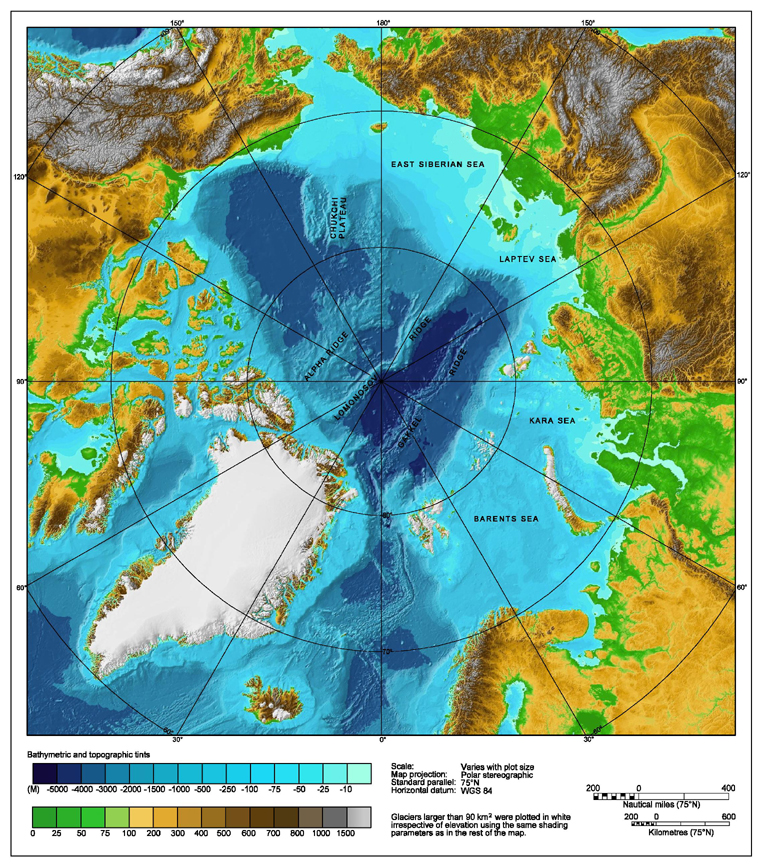
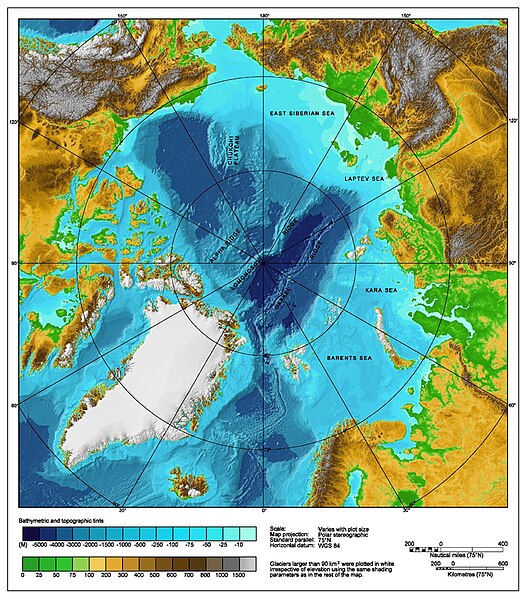
Bathymetric map of the Arctic Ocean |
|||||||||
| स्रोत | http://www.ngdc.noaa.gov/mgg/image/IBCAO_betamap.jpg | |||||||||
| परमीशन (एह फाइल के दुबारा इस्तेमाल) |
|
|||||||||
| Geotemporal data | ||||||||||
| Bounding box |
|
|||||||||
| Georeferencing | ||||||||||
| Other versions |
Derivative works of this file: |
|||||||||
फाइल के इतिहास
ओ समय ई फाइल कइसन लउके ई देखे खातिर कौनों तारीख/समय पर क्लिक करीं।
| तारीख/समय | चिप्पी रूप | डाइमेंशन | प्रयोगकर्ता | टिप्पणी | |
|---|---|---|---|---|---|
| वर्तमान | 00:29, 2 अगस्त 2007 | | 762 × 868 (710 KB) | Mikkalai | Source: http://www.ngdc.noaa.gov/mgg/image/IBCAO_betamap.jpg Bathymetric map of the w:Arctic Ocean |
फाइल के उपयोग
फाइल के इस्तेमाल पन्ना करत बा:
बैस्विक फाइल उपयोग
नीचे दिहल अउरी विकिसभ पर एह फाइल के इस्तेमाल हो रहल बा:
- af.wikipedia.org पर इस्तेमाल
- ar.wikipedia.org पर इस्तेमाल
- ary.wikipedia.org पर इस्तेमाल
- ast.wikipedia.org पर इस्तेमाल
- avk.wikipedia.org पर इस्तेमाल
- azb.wikipedia.org पर इस्तेमाल
- bcl.wikipedia.org पर इस्तेमाल
- be.wikipedia.org पर इस्तेमाल
- bg.wikipedia.org पर इस्तेमाल
- bn.wikipedia.org पर इस्तेमाल
- bxr.wikipedia.org पर इस्तेमाल
- ca.wikipedia.org पर इस्तेमाल
- ceb.wikipedia.org पर इस्तेमाल
- chr.wikipedia.org पर इस्तेमाल
- co.wikipedia.org पर इस्तेमाल
- crh.wikipedia.org पर इस्तेमाल
- cs.wikipedia.org पर इस्तेमाल
- da.wikipedia.org पर इस्तेमाल
- de.wikipedia.org पर इस्तेमाल
- dty.wikipedia.org पर इस्तेमाल
- en.wikipedia.org पर इस्तेमाल
- Talk:Lomonosov Ridge
- Territorial claims in the Arctic
- Arktika 2007
- Portal:Maps/Maps/Geographic
- Portal:Maps/Maps/Geographic/2
- Arctic Ocean
- User:Wiki User 68/My Portal/Selected geography/1
- List of Russian explorers
- Wikipedia:Reference desk/Archives/Science/2015 May 29
- User:Joelton Ivson/Gather lists/24441 – Conflitos internacionais
- Portal:Oceans
- en.wikinews.org पर इस्तेमाल
- en.wikiversity.org पर इस्तेमाल
- eo.wikipedia.org पर इस्तेमाल
- es.wikipedia.org पर इस्तेमाल
एह फाइल के अउरी बैस्विक इस्तेमाल देखीं