
चित्र:Goa locator map.svg

Size of this PNG preview of this SVG file: 274 × 331 पिक्सेल. अउरी रिजोल्यूशन: 199 × 240 पिक्सेल | 397 × 480 पिक्सेल | 636 × 768 पिक्सेल | 848 × 1,024 पिक्सेल | 1,695 × 2,048 पिक्सेल.
ओरिजनल फाइल (एसवीजी फाइल, नॉमिनली 274 x 331 पिक्सल, फाइल के आकार: 93 KB)
| Title |
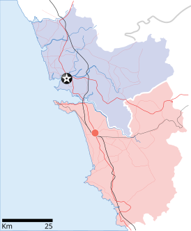
Goa locator map |
| Description |
Locator map for the state of w:Goa. Coordinates: top=15.811, bottom=14.861, left=73.567, right=74.287. |
| तारीख | |
| स्रोत |
आपन रचना |
| Creator | |
| परमीशन (एह फाइल के दुबारा इस्तेमाल) |
I, the copyright holder of this work, hereby publish it under the following license: ई फाइल Creative Commons Attribution-Share Alike 3.0 Unported लाइसेंस की तहत लाइसेंसी बा।
|
| Geotemporal data | |
| Date depicted | second half of 20 century अउर 21 century |
| Georeferencing | If inappropriate please set warp_status = skip to hide. |
| Archival data | |
| Notes | Part of WikiProject India Maps |
फाइल के इतिहास
ओ समय ई फाइल कइसन लउके ई देखे खातिर कौनों तारीख/समय पर क्लिक करीं।
| तारीख/समय | चिप्पी रूप | डाइमेंशन | प्रयोगकर्ता | टिप्पणी | |
|---|---|---|---|---|---|
| वर्तमान | 10:48, 26 अप्रैल 2007 | | 274 × 331 (93 KB) | Planemad | upd |
| 10:40, 26 अप्रैल 2007 |  | 274 × 331 (80 KB) | Planemad | upd | |
| 18:27, 9 अप्रैल 2007 |  | 274 × 331 (66 KB) | Planemad | {{WikiProject_India_Maps |Title=Goa locator map |Description=Locator map for the state of [w:Goa]] |Source= [http://www.bombayproperty.com/goamap.jpg Map of Goa], |Date=April 2007 |Author=w:user:Planemad }} Category:WikiProject India State Maps |
फाइल के उपयोग
कौनों पन्ना नइखे जवन ए फाइल के इस्तेमाल करत होखे।
बैस्विक फाइल उपयोग
नीचे दिहल अउरी विकिसभ पर एह फाइल के इस्तेमाल हो रहल बा:
- ar.wikipedia.org पर इस्तेमाल
- ba.wikipedia.org पर इस्तेमाल
- ceb.wikipedia.org पर इस्तेमाल
- cy.wikipedia.org पर इस्तेमाल
- de.wikipedia.org पर इस्तेमाल
- en.wikipedia.org पर इस्तेमाल
- Farmagudi
- Zuari River
- Pilar, Goa
- Bardez
- Sonsogor
- Flora and fauna of Goa
- Sanguem
- Mollem, Goa
- Dabolim
- Template:Goa-geo-stub
- Aquem
- Bambolim
- Bandora, Goa
- Canacona
- Karapur
- Chicalim
- Chimbel
- Colvale
- Curti, Goa
- Davorlim
- Parcem
- Penha de França, Goa
- Queula
- Sancoale
- Sanquelim
- Sanvordem
- São José de Areal
- Valpoi
- Arpora
- Altinho, Goa
- Mardol, Goa
- Gokarna Math
- Baga, Goa
- Baga Creek
- Chapora Beach
- Terekhol River
- Kasarpal
- Revora
- Pale, Goa
- Agaçaim
- Priol
- Betul, Goa
- Bogmalo
- Adas Bank
- St Inez Creek
एह फाइल के अउरी बैस्विक इस्तेमाल देखीं