
चित्र:Celtic Sea and Bay of Biscay bathymetric map-en.svg

Size of this PNG preview of this SVG file: 548 × 599 पिक्सेल. अउरी रिजोल्यूशन: 219 × 240 पिक्सेल | 439 × 480 पिक्सेल | 702 × 768 पिक्सेल | 936 × 1,024 पिक्सेल | 1,872 × 2,048 पिक्सेल | 3,479 × 3,805 पिक्सेल.
ओरिजनल फाइल (एसवीजी फाइल, नॉमिनली 3,479 x 3,805 पिक्सल, फाइल के आकार: 4.93 MB)
सारांश
| बिबरण |
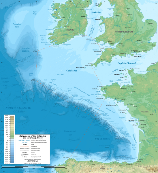
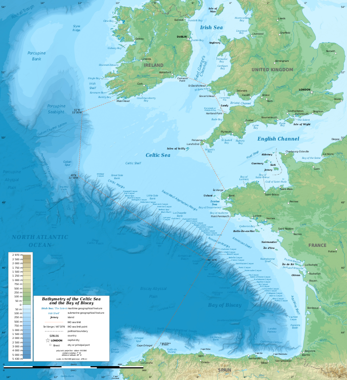
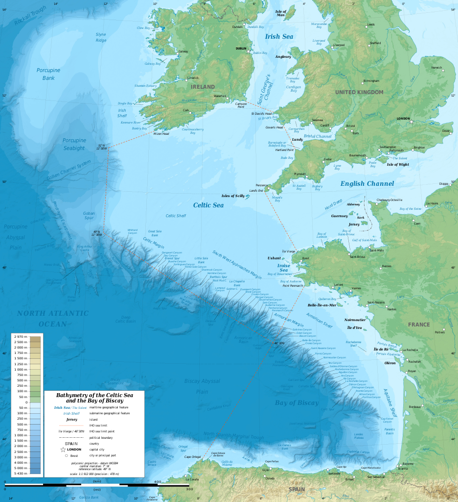
English: Bathymetric map in English of the Celtic Sea and the Bay of Biscay. Limits of the seas as specified by the International Hydrographic Organization.
Note: the background map is a raster image embedded in the SVG file. Français : Carte bathymétrique en anglais de la Mer Celtique et du Golfe de Gascogne. Limites des mers telles que définies par l'Organisation Hydrographique Internationale. Note : le fond de carte est une image bitmap embarquée dans le fichier SVG. |
| तारीख | 13:37:01, upgraded 2019-10 |
| स्रोत | see Celtic Sea and Bay of Biscay bathymetric map-fr.svg |
| लेखक | Eric Gaba (Sting - fr:Sting) |
| Other versions |
[]
|
| SVG genesis |


| Camera location | | View this and other nearby images on: OpenStreetMap |
|---|
लाइसेंसिंग
ई फाइल Creative Commons Attribution-Share Alike 3.0 Unported लाइसेंस की तहत लाइसेंसी बा।
- आप फ्री बानी:
- साझा करे खातिर – रचना के नकल करे, बाँटे आ दुसरी जगह भेजे खातिर
- रीमिक्स करे खातिर – काम के अपनी हिसाब से बनावे खातिर
- नीचे दिहल कारणन की तहत:
- एट्रीब्यूशन – लाइसेंस के कड़ी दे के उचित श्रेय (क्रेडिट) दिहल जरूरी बा आ अगर कौनों बदलाव कइल गइल बा तब ओहू के बतावल जाए के चाहीं। आप ई काम कौनों उचित तरीका से क सकत बानी, बाकी ई न झलके के चाहीं की जेकरा लगे लाइसेंस बा ऊ राउर चाहे राउर काम के समर्थन करत बाटे या सही बतावत बा।
- शेयर अलाइक (share alike) – अगर आप एह सामग्री के आधार बना के कुछ रिमिक्स करत बानी, रूप बदलाव करत बानी, चाहे कुछ जोड़ के सामग्री के बढ़ावत बानी, आपके आपन योगदान ठीक एही या कंपेटिबल लाइसेंस जइसन कि ओरिजनल बाटे, के तहत होखे के चाहीं।
फाइल के इतिहास
ओ समय ई फाइल कइसन लउके ई देखे खातिर कौनों तारीख/समय पर क्लिक करीं।
| तारीख/समय | चिप्पी रूप | डाइमेंशन | प्रयोगकर्ता | टिप्पणी | |
|---|---|---|---|---|---|
| वर्तमान | 21:33, 28 अक्टूबर 2019 | | 3,479 × 3,805 (4.93 MB) | Sting | New map using GEBCO 15 Sec topographic data ; rivers from ECRINS ; added names |
| 14:34, 3 जुलाई 2014 |  | 1,749 × 1,913 (673 KB) | Erigena | minor tweaks | |
| 12:46, 1 जुलाई 2014 |  | 1,749 × 1,913 (614 KB) | Erigena | User created page with UploadWizard |
फाइल के उपयोग
फाइल के इस्तेमाल पन्ना करत बा:
बैस्विक फाइल उपयोग
नीचे दिहल अउरी विकिसभ पर एह फाइल के इस्तेमाल हो रहल बा:
- af.wikipedia.org पर इस्तेमाल
- azb.wikipedia.org पर इस्तेमाल
- bg.wikipedia.org पर इस्तेमाल
- bn.wikipedia.org पर इस्तेमाल
- cs.wikipedia.org पर इस्तेमाल
- de.wikipedia.org पर इस्तेमाल
- en.wikipedia.org पर इस्तेमाल
- en.wikiversity.org पर इस्तेमाल
- fa.wikipedia.org पर इस्तेमाल
- fi.wikipedia.org पर इस्तेमाल
- frr.wikipedia.org पर इस्तेमाल
- fy.wikipedia.org पर इस्तेमाल
- gl.wikipedia.org पर इस्तेमाल
- hu.wikipedia.org पर इस्तेमाल
- hy.wikipedia.org पर इस्तेमाल
- hyw.wikipedia.org पर इस्तेमाल
- id.wikipedia.org पर इस्तेमाल
- ja.wikipedia.org पर इस्तेमाल
- lo.wikipedia.org पर इस्तेमाल
- lv.wikipedia.org पर इस्तेमाल
- nl.wikipedia.org पर इस्तेमाल
- ru.wikipedia.org पर इस्तेमाल
- sq.wikipedia.org पर इस्तेमाल
- sr.wikipedia.org पर इस्तेमाल
- sv.wikipedia.org पर इस्तेमाल
- tg.wikipedia.org पर इस्तेमाल
- th.wikipedia.org पर इस्तेमाल
- tr.wikipedia.org पर इस्तेमाल
- uk.wikipedia.org पर इस्तेमाल
- vi.wikipedia.org पर इस्तेमाल
- vls.wikipedia.org पर इस्तेमाल
- www.wikidata.org पर इस्तेमाल
- zh-min-nan.wikipedia.org पर इस्तेमाल
- zh-yue.wikipedia.org पर इस्तेमाल
- zh.wikipedia.org पर इस्तेमाल