
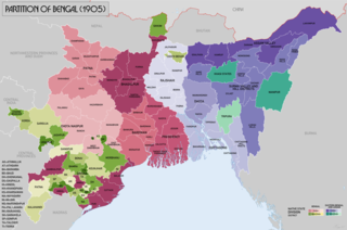
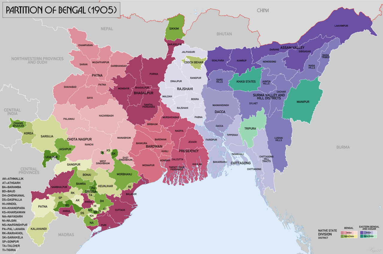
चित्र:BengalPartition1905 Map.png

ए नमूना के साइज: 800 × 530 पिक्सेल. अउरी रिजोल्यूशन: 320 × 212 पिक्सेल | 640 × 424 पिक्सेल | 1,024 × 679 पिक्सेल | 1,280 × 849 पिक्सेल | 3,000 × 1,989 पिक्सेल.
ओरिजनल फाइल (3,000 × 1,989 पिक्सेल, फाइल साइज: 1.19 MB, MIME टाइप: image/png)
सारांश
| बिबरण |
English: Map of showing the partition of Lower Bengal between Bengal and East Bengal and Assam in 1905. Source data: Survey of India 1:253k (Perry-Castenada Map Library, Univ of Texas), India 1:1M, Imperial Gazetteer of India 1:4M (Digital South Asia Library, Univ of Chicago). |
| तारीख | |
| स्रोत | आपन रचना |
| लेखक | XrysD |
लाइसेंसिंग
I, the copyright holder of this work, hereby publish it under the following license:
This file is licensed under the Creative Commons Attribution-Share Alike 4.0 International license.
- आप फ्री बानी:
- साझा करे खातिर – रचना के नकल करे, बाँटे आ दुसरी जगह भेजे खातिर
- रीमिक्स करे खातिर – काम के अपनी हिसाब से बनावे खातिर
- नीचे दिहल कारणन की तहत:
- एट्रीब्यूशन – लाइसेंस के कड़ी दे के उचित श्रेय (क्रेडिट) दिहल जरूरी बा आ अगर कौनों बदलाव कइल गइल बा तब ओहू के बतावल जाए के चाहीं। आप ई काम कौनों उचित तरीका से क सकत बानी, बाकी ई न झलके के चाहीं की जेकरा लगे लाइसेंस बा ऊ राउर चाहे राउर काम के समर्थन करत बाटे या सही बतावत बा।
- शेयर अलाइक (share alike) – अगर आप एह सामग्री के आधार बना के कुछ रिमिक्स करत बानी, रूप बदलाव करत बानी, चाहे कुछ जोड़ के सामग्री के बढ़ावत बानी, आपके आपन योगदान ठीक एही या कंपेटिबल लाइसेंस जइसन कि ओरिजनल बाटे, के तहत होखे के चाहीं।
फाइल के इतिहास
ओ समय ई फाइल कइसन लउके ई देखे खातिर कौनों तारीख/समय पर क्लिक करीं।
| तारीख/समय | चिप्पी रूप | डाइमेंशन | प्रयोगकर्ता | टिप्पणी | |
|---|---|---|---|---|---|
| वर्तमान | 11:33, 20 नवंबर 2017 | | 3,000 × 1,989 (1.19 MB) | XrysD | Added missing labels for Ranchi and Palamau districts. Removed Lohardaga label. |
| 11:18, 20 नवंबर 2017 |  | 3,000 × 1,989 (1.19 MB) | XrysD | User created page with UploadWizard |
फाइल के उपयोग
फाइल के इस्तेमाल पन्ना करत बा:
बैस्विक फाइल उपयोग
नीचे दिहल अउरी विकिसभ पर एह फाइल के इस्तेमाल हो रहल बा:
- as.wikipedia.org पर इस्तेमाल
- bn.wikipedia.org पर इस्तेमाल
- en.wikipedia.org पर इस्तेमाल
- eo.wikipedia.org पर इस्तेमाल
- hi.wikipedia.org पर इस्तेमाल
- it.wikipedia.org पर इस्तेमाल
- kn.wikipedia.org पर इस्तेमाल
- mt.wikipedia.org पर इस्तेमाल
- pt.wikipedia.org पर इस्तेमाल
- ru.wikipedia.org पर इस्तेमाल
- ta.wikipedia.org पर इस्तेमाल
- uk.wikipedia.org पर इस्तेमाल
- ur.wikipedia.org पर इस्तेमाल