
चित्र:Ile-de-France region location map.svg

Size of this PNG preview of this SVG file: 742 × 600 पिक्सेल. अउरी रिजोल्यूशन: 297 × 240 पिक्सेल | 594 × 480 पिक्सेल | 951 × 768 पिक्सेल | 1,267 × 1,024 पिक्सेल | 2,535 × 2,048 पिक्सेल | 1,651 × 1,334 पिक्सेल.
ओरिजनल फाइल (एसवीजी फाइल, नॉमिनली 1,651 x 1,334 पिक्सल, फाइल के आकार: 944 KB)
सारांश
| Camera location | | View this and other nearby images on: OpenStreetMap |
|---|
| बिबरण |
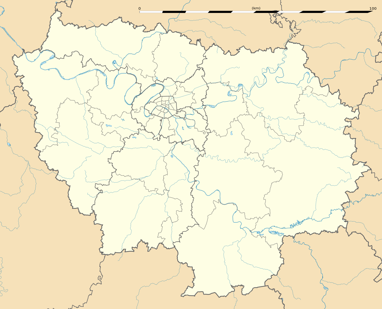
English: Blank administrative map of the region of Île-de-France, France, as in January 2015, for geo-location purpose, with distinct boundaries for regions, departments and arrondissements.
Français : Carte administrative vierge de la région Île-de-France, France, telle qu'en janvier 2015, destinée à la géolocalisation, avec limite distincte des régions, départements et arrondissements. Estimated scale: 1:400,000 (precision: 100 m)
Geographic limits of the map:
|
||
| तारीख | |||
| स्रोत |
आपन रचना
|
||
| लेखक | Eric Gaba (Sting - fr:Sting) | ||
| परमीशन (एह फाइल के दुबारा इस्तेमाल) |
|
||
| Other versions |
|

लाइसेंसिंग
Eric Gaba, Wikimedia Commons user Sting, the copyright holder of this work, hereby publishes it under the following license:
ई फाइल Creative Commons Attribution-Share Alike 3.0 Unported लाइसेंस की तहत लाइसेंसी बा।
एट्रीब्यूशन: Eric Gaba, Wikimedia Commons user Sting
- आप फ्री बानी:
- साझा करे खातिर – रचना के नकल करे, बाँटे आ दुसरी जगह भेजे खातिर
- रीमिक्स करे खातिर – काम के अपनी हिसाब से बनावे खातिर
- नीचे दिहल कारणन की तहत:
- एट्रीब्यूशन – लाइसेंस के कड़ी दे के उचित श्रेय (क्रेडिट) दिहल जरूरी बा आ अगर कौनों बदलाव कइल गइल बा तब ओहू के बतावल जाए के चाहीं। आप ई काम कौनों उचित तरीका से क सकत बानी, बाकी ई न झलके के चाहीं की जेकरा लगे लाइसेंस बा ऊ राउर चाहे राउर काम के समर्थन करत बाटे या सही बतावत बा।
- शेयर अलाइक (share alike) – अगर आप एह सामग्री के आधार बना के कुछ रिमिक्स करत बानी, रूप बदलाव करत बानी, चाहे कुछ जोड़ के सामग्री के बढ़ावत बानी, आपके आपन योगदान ठीक एही या कंपेटिबल लाइसेंस जइसन कि ओरिजनल बाटे, के तहत होखे के चाहीं।
फाइल के इतिहास
ओ समय ई फाइल कइसन लउके ई देखे खातिर कौनों तारीख/समय पर क्लिक करीं।
| तारीख/समय | चिप्पी रूप | डाइमेंशन | प्रयोगकर्ता | टिप्पणी | |
|---|---|---|---|---|---|
| वर्तमान | 15:21, 12 फरवरी 2015 | | 1,651 × 1,334 (944 KB) | Sting | Boundaries correction |
| 16:25, 22 जनवरी 2015 |  | 1,651 × 1,334 (945 KB) | Sting | Boundaries correction | |
| 14:03, 21 जनवरी 2015 |  | 1,651 × 1,334 (943 KB) | Sting | == {{int:filedesc}} == {{Location|48|40|30|N|02|30|00|E|scale:1000000}} {{Information |Description={{en|Blank administrative map of the region of Île-de-France, France, as in January 2015, for geo-location purpose, with distinct... |
फाइल के उपयोग
फाइल के इस्तेमाल 3 पन्ना करत बाड़ें:
बैस्विक फाइल उपयोग
नीचे दिहल अउरी विकिसभ पर एह फाइल के इस्तेमाल हो रहल बा:
- af.wikipedia.org पर इस्तेमाल
- als.wikipedia.org पर इस्तेमाल
- ast.wikipedia.org पर इस्तेमाल
- azb.wikipedia.org पर इस्तेमाल
- پاریس
- ارژانتوی
- کولومب فرانسه
- کوربوآ
- ورسای
- کرتی
- ویتری-سور-سن
- سرژی
- لوالوآ-پره
- ایسی-له-مولینو
- سن-مر-د-فوسه
- روی ملمزون
- اپینه-سور-سن
- اتی مون
- اوی، ایولین
- ایوری-سور-سن
- آلفورویل
- برتینی-سور-ارژ
- برونوآ
- بری-سور-مرن
- بنیوله
- بوآ-کلمب
- بوبینی
- بوندی
- پلزو
- پونتوآز
- پیروفیت سور سن
- ترامبله آنفرانس
- دروی
- دمری للیس
- دوی لبر
- روزنی سو بوآ
- ری اورانژی
- ژنویلیه
- ژیف سور ایوت
- سن-مانده
- سن ژرمن آن له
- سن کلو
- سن میشل سور اورژ
- سورزن
- سوینیی سور اورژ
- شاتنه-ملبری
- شام سور مرن
- شتو
- شرانتون-لو-پون
एह फाइल के अउरी बैस्विक इस्तेमाल देखीं