
चित्र:China-Special Administrative Regions.png
ए से उच्च गुणवत्ता उपलब्ध नइखे।
China-Special_Administrative_Regions.png (400 × 202 पिक्सेल, फाइल साइज: 47 KB, MIME टाइप: image/png)

|
This map image could be re-created using vector graphics as an SVG file. This has several advantages; see Commons:Media for cleanup for more information. If an SVG form of this image is available, please upload it and afterwards replace this template with
{{vector version available|new image name}}.
It is recommended to name the SVG file “China-Special Administrative Regions.svg”—then the template Vector version available (or Vva) does not need the new image name parameter. |
सारांश
| बिबरण |
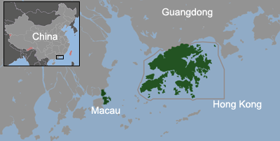
English: The location of SARs within the Pearl River Delta The map also shows the maritime boundary of Hong Kong since July 1 1997 and Macau since December 20, 1999 .
Español: Localización de las RR.AA.EE. en el Delta del Río Perla. El mapa muestra los límetes marítimos de Hong Kong desde 1-6-1997 y de Macao 20-12-1999. |
||||||||
| तारीख | |||||||||
| स्रोत | Previously based on en:File:Image-Special Administrative Region of the People's Republic of China.png | ||||||||
| लेखक | Alanmak, Serg!o, ASDFGH | ||||||||
| परमीशन (एह फाइल के दुबारा इस्तेमाल) |
|
||||||||
| Other versions | Derivative works of this file: China-Special Administrative Regions-fr.png |

फाइल के इतिहास
ओ समय ई फाइल कइसन लउके ई देखे खातिर कौनों तारीख/समय पर क्लिक करीं।
| तारीख/समय | चिप्पी रूप | डाइमेंशन | प्रयोगकर्ता | टिप्पणी | |
|---|---|---|---|---|---|
| वर्तमान | 01:11, 22 जून 2011 | | 400 × 202 (47 KB) | ASDFGH | add Macau Airport |
| 00:11, 20 अक्टूबर 2009 |  | 400 × 202 (42 KB) | Serg!o | {{Information |Description={{en|The location of SARs within the Pearl River Delta The map also shows the maritime boundary of Hong Kong since July 1 1997 and Macau since December 20, 1999 .}} {{es|Localización de las RR.AA.EE. en el Delta del Río Perla |
फाइल के उपयोग
फाइल के इस्तेमाल पन्ना करत बा:
बैस्विक फाइल उपयोग
नीचे दिहल अउरी विकिसभ पर एह फाइल के इस्तेमाल हो रहल बा:
- azb.wikipedia.org पर इस्तेमाल
- ca.wikipedia.org पर इस्तेमाल
- cs.wikipedia.org पर इस्तेमाल
- en.wikipedia.org पर इस्तेमाल
- es.wikipedia.org पर इस्तेमाल
- fa.wikipedia.org पर इस्तेमाल
- fi.wikipedia.org पर इस्तेमाल
- fr.wikipedia.org पर इस्तेमाल
- he.wikipedia.org पर इस्तेमाल
- hi.wikipedia.org पर इस्तेमाल
- hu.wikipedia.org पर इस्तेमाल
- ka.wikipedia.org पर इस्तेमाल
- lmo.wikipedia.org पर इस्तेमाल
- no.wikipedia.org पर इस्तेमाल
- ps.wikipedia.org पर इस्तेमाल
- pt.wikipedia.org पर इस्तेमाल
- ro.wikipedia.org पर इस्तेमाल
- simple.wikipedia.org पर इस्तेमाल
- sk.wikipedia.org पर इस्तेमाल
- th.wikipedia.org पर इस्तेमाल
- uk.wikipedia.org पर इस्तेमाल
- ur.wikipedia.org पर इस्तेमाल
- vi.wikipedia.org पर इस्तेमाल
- zh.wikipedia.org पर इस्तेमाल